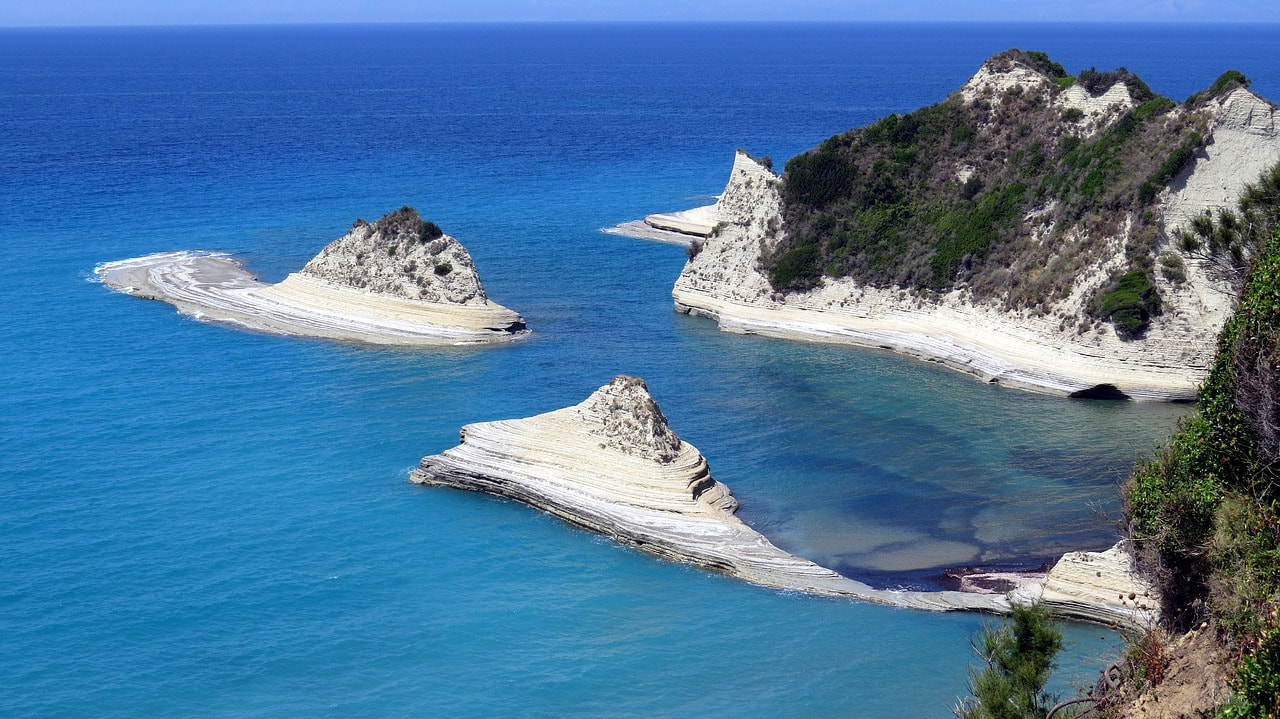
 The boats presented are indicative. We will give you specific suggestions upon your request so don't hesitate to comunicate with us! Feel the warmth of the greek sunlight to your skin, enjoy the crystal clear waters and gaze upon the horizon  Attractions The city of Reggio Calabria is located at the tip of the "Stivale", on the slopes of the Aspromonte Park, on the eastern shore of the Strait of Messina, from which it enjoys a spectacular view of Sicily, Mount Etna and the Aeolian Islands. Traditionally it is called Città della Fata Morgana because here the rare optical-mythological phenomenon of the Fata Morgana manifests itself, during which the Sicilian coast seems to be only a few meters away making it possible to distinguish houses, cars and people very well.
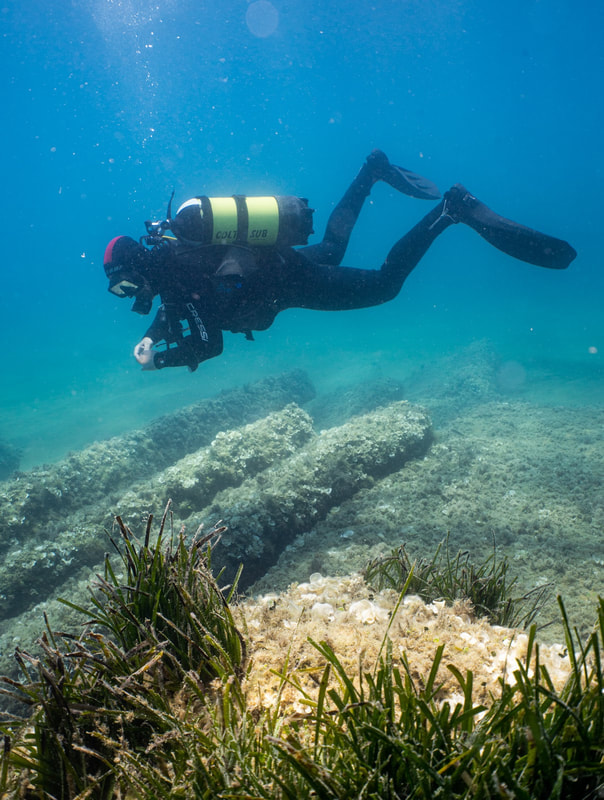
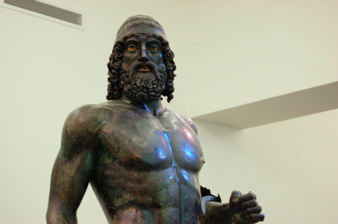 Reggio Calabria The city hosts the National Museum of Magna Graecia, housing an archaeological collection from sites in Magna Graecia. In this structure there are exposed various objects from excavation campaigns in the ancient city-states of Calabria, Basilicata and Sicily, including the Riace Bronzes, one of the symbols of Magna Graecia. They are extremely important for studies of the 8th century BC, but also have several objects from the prehistoric and protohistoric periods, which preceded it and the following ancient Roman and Byzantine eras. Reggio Calabria is a city of art and science, jealous of the inheritance of its glorious past but outstretched towards a future of development and progress. The National Archaeological Museum preserves magnificent and ancient memories of the prehistoric, Greek and Roman eras, and the vigorous Riace warriors seem to defend such a great richness. Museum hosts also a section dedicated to underwater archaeology, which has opened their first display area with information panels explaining and detailing the ancient maritime routes along the Calabrian coast. A collection of anchors in lead and of vases, from various locations and dates, demonstrates the navigational patterns in this area for the whole of the Greek and Roman period. A glass display case exhibits relics recovered from a naval wreck (dating from the end of the 5th century BC) located in 1969 near the port of Villa San Giovanni: the objects found are articles of everyday use (fishing equipment and crockery) along with globe vases, which may have contained ink (probably for commercial exchange). In the adjacent case relics found at Riace Marina (1972 – 1973) are displayed, from the sea bed where the “Bronzi” were recovered: 28 lead rings belonging to the sails of an ancient ship, a fragment of keel which has been identified as being from Roman or Byzantine period, the handle of the shield held by “Bronzo A”, and the lead tethers which held the statue’s feet to its base. Today new finds in Calabria are no longer displayed and conserved in a single museum, but exhibited where they have been found, since the quantity of new discoveries has allowed smaller local museums to be set up for them (at Crotone, Locri, Roccelletta di Borgia, Sibari, Vibo Valentia and Lamezia Terme). These are taken together as the Museo Reggino. 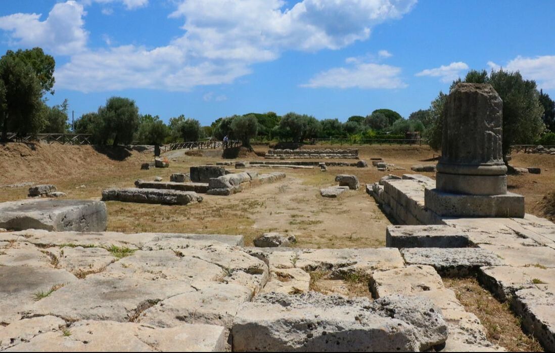 Locri Epizephiri The millenarian history of Locri Epizephyrii (in Greek, Λοκροί Επιζεφύριοι) begins between the VIII and the VII century B.C. with the arrival, on the shores of southern Calabria, of a group of settlers from Locris, a poor region of the ancient Greece. From that moment onward, the history of the city develops in the course of the ages and it is studded by many meaningful events: from the magnificence of the archaic age and the alliance with Syracuse to the difficult impact with the Roman world; from the new positive dimension of Municipium to the unavoidable decline that will carry the city to drag itself on until the VII and the VIII century AD, when some environmental problems (lack of resources and spreading of malaria) added to the increasingly violence of Arab raids, pushed the last inhabitants of the zone to take shelter on the near mountains and, from then on, to contribute to the development of a new city: Gerace. The polis of Locri Epizephyrii was ruled following a typical Greek model. A strict conservative aristocracy exercised the power through the "one-thousand assembly", which was probably composed by all the citizens in charge of full political rights; also the population was divided in three tribes and thirty-six phratries. Between the VII and the VI century BC the development of the polis was well underway; the city flourished with a strict and organized urban plan, and its sanctuaries with their cults were already well recognized almost everywhere in the Greek world. The internal situation was, as it has been already pointed out, ideal to start planning an expansion of the control over the territory around the city, even with the creation of some sub-colonies. That was necessary because, more than the need of control over a larger portion of territory, there was the risk that the great demographic increase of that age could harm the social equilibrium reached by the polis. Therefore, probably during the end of the VII century BC, Medma (the modern Rosarno) and Hipponion (the modern Vibo Valentia) were founded on the Tyrrhenian coast. By this time, with the foundation of these two sub-colonies, Locri Epizephyrii took the control of a large part of territory, spreading from the Ionian to the Tyrrhenian coasts and embracing the mountains between the two seas; this expansion created the conditions for the historical clashes against Kroton and Rhegion, cities which began to see in Locri Epizephyrii a dangerous problem for their future expansion. 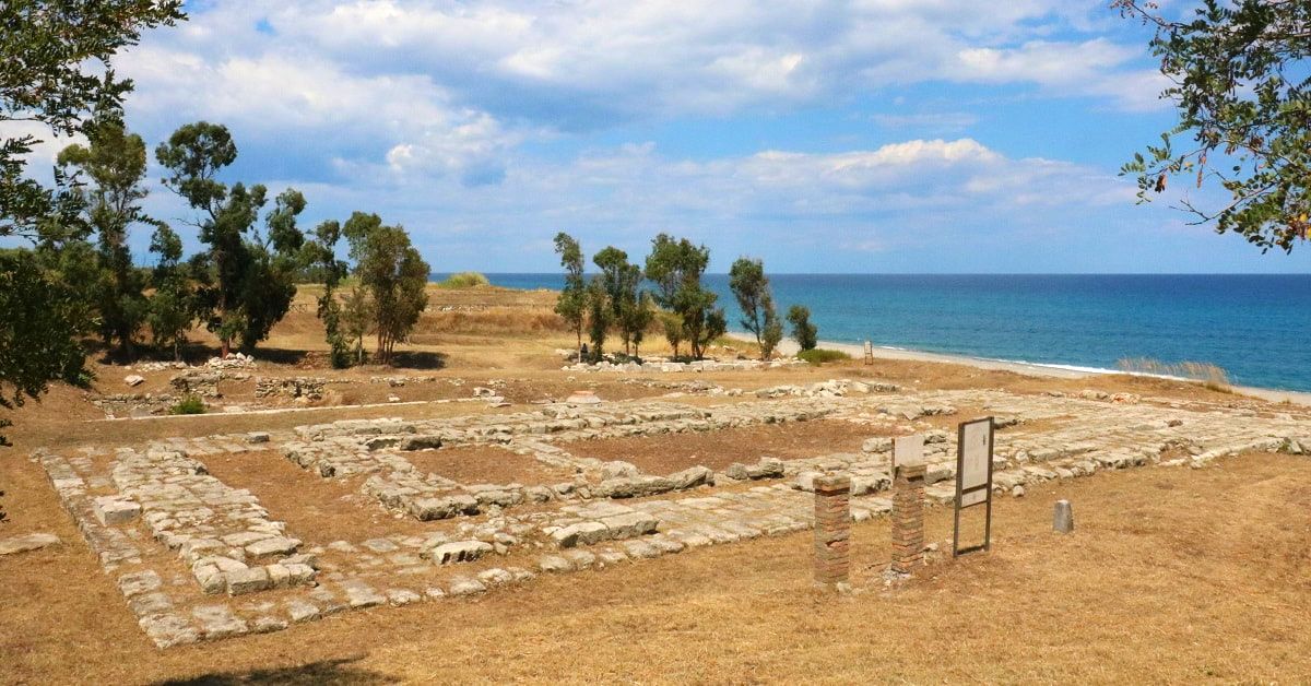 Kaulonia The archaeological area of the ancient Greek city of Kaulon (or rather Kaulonia) lies near Punta Stilo, in the territory of the municipality of Monasterace Marina, along the Ionian coast of the province of Reggio Calabria. It is made up of both the Archaeological Park with a nice little Museum and the Archaeological Underwater Area in the sea section in front of the Park, where it’s possible to dive to see the underwater Archaeological Site of Kaulonia. Over the centuries, due to a progressive phenomenon of coastal erosion and bradyseism, there has been a profound change in the coastline, which is backward compared to the age of the Greek colony. According to recent geo-archaeological studies, it appears that the coastline in front of the Kaulonia city, in the Greek age, was about 300 m further to the east than the present, as well as being characterised by a slightly arched shape. This wide area, time ago on the surface, is currently in the range of 7.5 m to 5 m deep and is characterised by the presence of many architectural elements, completed or semi-finished. These are pieces of columns (parts of the stem) and bases of grooved ionic columns, squared blocks of various sizes, rough hollow blocks and mooring bits. This important underwater site, made up of more than 200 finds, has been interpreted as an area of work of architectural elements or as a temple under construction, not completed for reasons still unclear. About the columns age, thanks to stylistic comparisons, it is probably set between 480 and 470 BC. The first excavations were undertaken at the beginning of the twentieth century and supervised by Archaeologist Paolo Orsi. They explored the sacred area, the Doric temple and part of the walls, then in the 1950s topographic and urban studies were conducted by Schmiedt and Chevallier. The excavation of the House of the Dragon is attributed to Alfonso De Franciscis, following his researches there were others investigating the temple, the walls and one of the residential areas. The archaeological investigations of the Ancient town of Kaulon started again only in the 1980s, thanks to the efforts of the Archaeological Superintendence of Calabria in collaboration with the national scholastic system and other institutions, both Italian and foreign. The researches made in the last decades studied almost exclusively the side of the town that oversees the sea: the temple area is being studied by the University of Pisa and the Scuola Normale Superiore; the vast complex of the Casa Matta is being investigated by the Archaeological Superintendence of Calabria with the contribution of the Mediterranean University of Reggio Calabria and the University of Calabria; while the University of Florence has been investigating the northern part of the ancient residential area, known as San Marco, since 2003. A path running parallel to the coastline, mimicking one of the main streets of the ancient city of Kaulon, allows visitors to observe the ruins of the residential area with its regular structure and its houses, preserved at the level of the foundations, starting from the buildings discovered in the area called San Marco, inhabited since the mid eight century B.C. Here were discovered some archaic structures to whose other buildings were superimposed, the “Casa del Personaggio Grottesco” (i.e. House of the Grotesque Character) built in the classical period and then a Hellenic period house on top of it. Continuing along the path, you get to the so-called Casa Matta (Crazy House), where they brought to light a luxury mansion that served different purposes in the course of time. In the same area you can see the ruins of a thermal complex, the so-called Thermal Baths of Nannon, boasting one of the most important and big mosaics of the Magna Graecia, the mosaic with dragons, dolphins and hippocampuses. In the last section of the itinerary you can see the sacred area with the Doric temple of which you can distinguish the base, the altar, the stairs and other structures of sacred character. Going back, a little road takes you to one of the most luxurious mansions of the ancient Kaulon, the House of the Dragon, where the mosaic now displayed in the museum was found. An underway located on the opposite side from the first will now lead you to a residential area at the feet of the hill of Punta Stilo’s lighthouse. The Archaeological Park also includes a wide underwater archaeological area, extending from the Doric temple to the Assi torrent, which is now submerged and under protection, and it coincides with a Hellenic period complex for the manufacturing of stone.  Punta Scifo The wreck lies in the bay of Scifo, just south of the promontory of Capo Colonna (ancient Lacinium promontoriu, site of the sanctuary dedicated to Hera). It lies on the seabed at a depth of 6.5 m and 160 m from the promontory of Capo Pellegrino, known locally as Punta Scifo. Discovered by Luigi Canfora in 1986, the wreck was investigated in 1987 by the Cooperativa Aquarius, directed by Alice Freschi, on behalf of the Archaeological Superintendency of Calabria. These investigations, including excavation and planning, remained largely unpublished. The site has been newly investigated using new technology and cataloguing has begun of the moveable finds (metal and ceramics) recovered during the 1987 campaign and largely forming part of the ship’s equipment. The archaeological deposit “Punta Scifo D” comprises over 50 marble artefacts belonging to the cargo of a stone transporting ship, which a preliminary study of the pottery and amphorae dates to the 3rd century A.D. The marbles, in the form of blocks and slabs, are all in the rough-hewn stage and some are very large weighing over 20 tons. Minero-petrographic and isotope analyses undertaken by Lorenzo Lazzarini, I.U.A.V (Venice) on a series of samples, indicate that this is Proconnesian marble quarried at the site of Saraylar on the Turkish island of Marmara. During the 2011 investigation, a photo-mosaic was made of the entire area where the stone elements lie and all of them were re-measured in order to determine the volume and weight of the cargo on the ship. The first results suggest that the “Punta Scifo D” ship transported one of the largest ancient stone cargoes discovered in the Mediterranean. Study and processing of the data is underway and this should make it possible to determine the original positions in stowage of the stone blocks and to understand what the maximum dimensions and hydro-static characteristics of the ship were. The few preserved timber remains from the hull showed the use of a double layer mortice and tenon construction technique. Like the marble’s provenance, some of the ships equipment (pottery and amphorae) was linked to productions in the Aegean-Microasiatic and Pontine area. 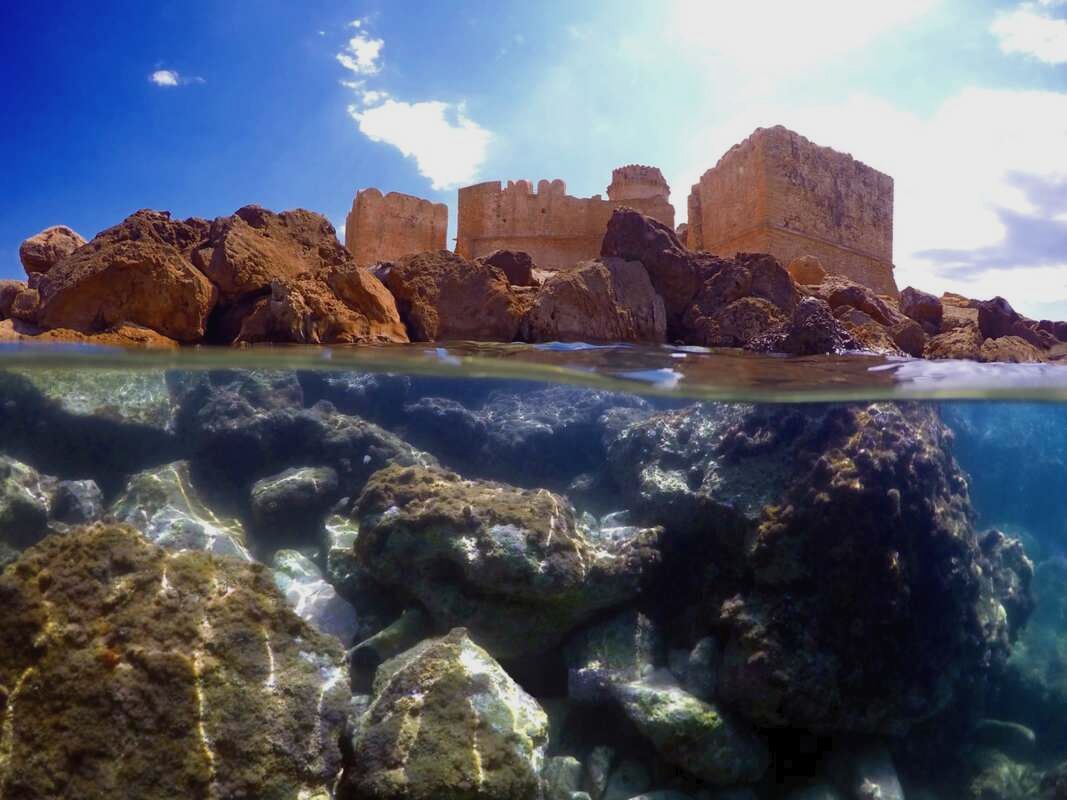 Le Castella Le Castella town of Isola Capo Rizzuto represents what remains of a more large ancient area. The fortress is surrounded by the Capo Rizzuto Marine Reserve and from one of the rooms it is possible to observe the seabed thanks to of underwater cameras positioned in marine environment. The fortress built in the fifteenth century never hosted the nobility of the place but served as a shelter for soldiers committed against attacks by invaders from the sea. The current stronghold rests on foundations dating back to the Hellenistic period, used over time also by the Romans was the retreat of Hannibal. Even today it is possible to notice the different building phases superimposed on each other in different periods, Normans, Swabians, Byzantines, Angevins and Aragoneses who raised on the Greek walls strong defences castellane modelled according to the times. The fortress continually attacked by the Turks, remained populated until the beginning of the 800, when the population moved to the mainland giving life to a small village of sailors, today the current tourist center. The original unit of the fort goes back to the Angevin Age, and the massive cylindrical tower as well. Now it has a sixteenth-century shape and it dominates the fortress complex with its magnificence. The original plant of 13th century was built to defend the Gulf of Capo Rizzuto, and it is part of the Angevin system of fortifications. Towards the end of the 15th century the fortress passed in Aragonese hands and between 1510 and 1526 Earl Carafa implemented, according to the Spanish construction uses, the quadrangular rammed bastions. The tower, divided into three floors connected by a spiral staircase, presents at the base a cavity for the collection and conservation of rainwater. Inside of fortress there are typical remains of an urban agglomeration, a kind of small village with shops and the ruins of a little church. Le Castella was often the centre of strong quarrels and subjected to pirates attacks: in 1459 the King Ferdinando of Aragon came down on the battlefield, against the noble feudatory, Antonio Centelles. Then Castella was submitted to different noble families such as Carafa, Ruffo, Filomarino, Baraccos and Berlingeris. Between 1548 and 1553 the pirates Dragut and Barbarossa pillaged the area. In 1799 Castella was still the centre both of the fight between French and Bourbons and the landing-place for the troops coming from Sicily. Later, Castella was included first in the district of Crotone and then it became a part of the Isola di Capo Rizzuto. Located nearby to the Aragonese fortress, “Le Castella” seabed hosts the ruins of an ancient Greek quarry along with those of an imposing wreck; while at “Capo Alfieri” site, divers will be able to explore some ancient Roman millstones. ARMATA BRANCALEONE FILM The Aragonese Fortress was chosen by Mario Monicelli to set some scenes of “Armata Brancaleone” movie. Brancaleone (Vittorio Gassman) succumbs ingloriously to the assault of Saracen pirates with his shabby company, after taking possession of the fiefdom, abandoned by the local population too. THE PIRATE UCCIALÌ Uluc Pasha, a powerful Turkish admiral, born in Le Castella, was kidnapped as a boy and became part of the ranks of Barbary pirates, up to the summit of the army and power. His ability and his strength as well as his origin particularly impressed the Italian companies of the sixteenth century. According to historical reconstructions, Giovan Dionigi Galeni was entering a convent to become a monk when, at 16, he was captured by the Algerian corsair Khayr al-Dīn Barbarossa in 1536, in Le Castella. The prisoner-boy was immediately put on the oars as a slave, but managed to survive thanks to an uncommon resistance and to the understanding of the enemy's codes. In this change, he was helped by contact with barbarian corsairs of Calabrian origin, including Ja 'Far Pascià, whose daughter he married, after having converted to Islam in order to be able to kill without a consequence a Turk from whom he had been offended. The audacity of the failed Calabrian friar was enormous. As a privateer he raged throughout the Mediterranean and carried out acts of reckless robbery. He landed the Sicilian and Neapolitan coasts and woods, captured ships, attacked towns and cities, until he went to Liguria in Civezza, currently in the province of Imperia, which managed to resist him gloriously and also attacked the Dalmatian town of Korcula. He tried to capture the Duke Emanuele Filiberto of Savoy. His sea races therefore also had wide-ranging political goals. It was said that he had even tried, through strong local support, to turn Calabria into a Turkish-dominated Muslim region, snatching it from the Spaniards. He first became commander of the fleet of Alexandria, then Pasha of Algiers, and finally bey (governor) of Tripoli, became admiral of the Ottoman fleet, fought in Lepanto. In Italy, the former aspiring monk was called "the renegade" or, popularly Uccialì, which derives from his Islamic name. He died in July 1587 in his palace on the hilltop of Top-Hana near Istanbul and left his many slaves and servants houses and possessions of property, concentrated in a village he founded and called "New Calabria". According to some reports, on his deathbed he would return to the Christian faith, but the Turkish historians denied this eventuality, given that already in life he had been offered fiefs and riches in Christian lands that he had always refused, preferring the freedom of which Christians converted to Islam at that time enjoyed.  Capo Colonna
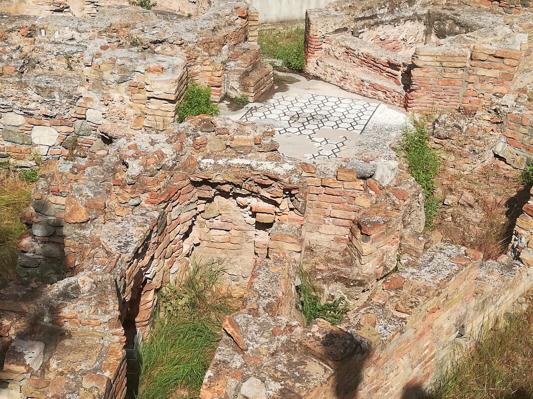
The promontory of Capo Colonna hosts the homonymous Archaeological Park, where anciently the great Heraion Lakinion was located. The Park extends along 30 hectares of land used as excavations, and another 20 hectares covered by a wood and the typical “Macchia Mediterranea”. The Heraion Lakinion was one of the most famous sacred areas of the entire Mediterranean basin related to the majestic sanctuary dedicated to the goddess Hera Lacinia. The entrance to the Park consists of the new Archaeological Museum, a structure with three pavilions built into the ground to reduce the environmental impact, which collects the finds found in the excavation area in front. A long tree-lined avenue, immersed in the luxuriant “Macchia Mediterranea”, leads to the first evidence of the Archaeological Park. At the end of the avenue, there are the walls of the VI century BC. They were reinforced later by the Romans and of which the opus reticolatum is clearly visible. Crossing the entrance of the Via Sacra, 8.5 meters wide and partially discovered in 1987, it is possible entering the area of the sanctuary of Hera Lacinia, well protected by the large curtain wall reinforced to the north and south by two external towers. The sacred area is divided into two zones oriented to the east, and crossed by the solemn Via Sacra. The Katagogion, a hotel for privileged pilgrims, is aligned towards the north side and shows a peristyle with stuccoed columns and capitals of the Doric order of the second half of the 4th century BC. The Hestiatorion, a building for banquets, located along the south side of the track is dated back to this period. The two buildings are not yet fully investigated. The temple of Hera Lacinia, the most important attraction of the park, is opposite the entrance of the Via Sacra, on the east side of the promontory of Capo Colonna. The temple was realized in Doric style with a rectangular plan of 6x19 columns and it dates back to the 5th century BC. Unfortunately today only a column with stilobate remains of the temple: Doric style, 8.5 meters high with 20 flat grooves, and the powerful base composed of 10 levels of squared blocks. It was found next to the temple the foundations of a large building called B with a rectangular plan of 22x9 meters. In the area outside the sanctuary, but still inside the Archaeological Park, various domestic environments have been excavated, suggesting the priests' quarters, a Roman bath balneum, and a Roman villa, both of the III century AD. The conspicuous objects found during the excavations in the Archaeological Park are divided among the different museums of the city of Crotone. The last discoveries are found in the new and adjacent Museum of Capo Colonna, while something of the pre-colonial era is exhibited in the Antiquarium of Torre Nao, located inside the Archaeological Park. The first finds of the Archaic period and above all the precious Treasure of Hera are placed in the National Archaeological Museum of Crotone.  Attractions
 Attractions
expanded by other donations. Today, with 15.000 Eastern objects of art, is the only museum in Greece devoted to Asian art.
 Locri Epizephiri
The millenarian history of Locri Epizephyrii (in Greek, Λοκροί Επιζεφύριοι) begins between the VIII and the VII century B.C. with the arrival, on the shores of southern Calabria, of a group of settlers from Locris, a poor region of the ancient Greece. From that moment onward, the history of the city develops in the course of the ages and it is studded by many meaningful events: from the magnificence of the archaic age and the alliance with Syracuse to the difficult impact with the Roman world; from the new positive dimension of Municipium to the unavoidable decline that will carry the city to drag itself on until the VII and the VIII century AD, when some environmental problems (lack of resources and spreading of malaria) added to the increasingly violence of Arab raids, pushed the last inhabitants of the zone to take shelter on the near mountains and, from then on, to contribute to the development of a new city: Gerace. The polis of Locri Epizephyrii was ruled following a typical Greek model. A strict conservative aristocracy exercised the power through the "one-thousand assembly", which was probably composed by all the citizens in charge of full political rights; also the population was divided in three tribes and thirty-six phratries. Between the VII and the VI century BC the development of the polis was well underway; the city flourished with a strict and organized urban plan, and its sanctuaries with their cults were already well recognized almost everywhere in the Greek world. The internal situation was, as it has been already pointed out, ideal to start planning an expansion of the control over the territory around the city, even with the creation of some sub-colonies. That was necessary because, more than the need of control over a larger portion of territory, there was the risk that the great demographic increase of that age could harm the social equilibrium reached by the polis. Therefore, probably during the end of the VII century BC, Medma (the modern Rosarno) and Hipponion (the modern Vibo Valentia) were founded on the Tyrrhenian coast. By this time, with the foundation of these two sub-colonies, Locri Epizephyrii took the control of a large part of territory, spreading from the Ionian to the Tyrrhenian coasts and embracing the mountains between the two seas; this expansion created the conditions for the historical clashes against Kroton and Rhegion, cities which began to see in Locri Epizephyrii a dangerous problem for their future expansion. Kaulonia The archaeological area of the ancient Greek city of Kaulon (or rather Kaulonia) lies near Punta Stilo, in the territory of the municipality of Monasterace Marina, along the Ionian coast of the province of Reggio Calabria. It is made up of both the Archaeological Park with a nice little Museum and the Archaeological Underwater Area in the sea section in front of the Park, where it’s possible to dive to see the underwater Archaeological Site of Kaulonia. Over the centuries, due to a progressive phenomenon of coastal erosion and bradyseism, there has been a profound change in the coastline, which is backward compared to the age of the Greek colony. According to recent geo-archaeological studies, it appears that the coastline in front of the Kaulonia city, in the Greek age, was about 300 m further to the east than the present, as well as being characterised by a slightly arched shape. This wide area, time ago on the surface, is currently in the range of 7.5 m to 5 m deep and is characterised by the presence of many architectural elements, completed or semi-finished. These are pieces of columns (parts of the stem) and bases of grooved ionic columns, squared blocks of various sizes, rough hollow blocks and mooring bits. This important underwater site, made up of more than 200 finds, has been interpreted as an area of work of architectural elements or as a temple under construction, not completed for reasons still unclear. About the columns age, thanks to stylistic comparisons, it is probably set between 480 and 470 BC. The first excavations were undertaken at the beginning of the twentieth century and supervised by Archaeologist Paolo Orsi. They explored the sacred area, the Doric temple and part of the walls, then in the 1950s topographic and urban studies were conducted by Schmiedt and Chevallier. The excavation of the House of the Dragon is attributed to Alfonso De Franciscis, following his researches there were others investigating the temple, the walls and one of the residential areas. The archaeological investigations of the Ancient town of Kaulon started again only in the 1980s, thanks to the efforts of the Archaeological Superintendence of Calabria in collaboration with the national scholastic system and other institutions, both Italian and foreign. The researches made in the last decades studied almost exclusively the side of the town that oversees the sea: the temple area is being studied by the University of Pisa and the Scuola Normale Superiore; the vast complex of the Casa Matta is being investigated by the Archaeological Superintendence of Calabria with the contribution of the Mediterranean University of Reggio Calabria and the University of Calabria; while the University of Florence has been investigating the northern part of the ancient residential area, known as San Marco, since 2003. A path running parallel to the coastline, mimicking one of the main streets of the ancient city of Kaulon, allows visitors to observe the ruins of the residential area with its regular structure and its houses, preserved at the level of the foundations, starting from the buildings discovered in the area called San Marco, inhabited since the mid eight century B.C. Here were discovered some archaic structures to whose other buildings were superimposed, the “Casa del Personaggio Grottesco” (i.e. House of the Grotesque Character) built in the classical period and then a Hellenic period house on top of it. Continuing along the path, you get to the so-called Casa Matta (Crazy House), where they brought to light a luxury mansion that served different purposes in the course of time. In the same area you can see the ruins of a thermal complex, the so-called Thermal Baths of Nannon, boasting one of the most important and big mosaics of the Magna Graecia, the mosaic with dragons, dolphins and hippocampuses. In the last section of the itinerary you can see the sacred area with the Doric temple of which you can distinguish the base, the altar, the stairs and other structures of sacred character. Going back, a little road takes you to one of the most luxurious mansions of the ancient Kaulon, the House of the Dragon, where the mosaic now displayed in the museum was found. An underway located on the opposite side from the first will now lead you to a residential area at the feet of the hill of Punta Stilo’s lighthouse. The Archaeological Park also includes a wide underwater archaeological area, extending from the Doric temple to the Assi torrent, which is now submerged and under protection, and it coincides with a Hellenic period complex for the manufacturing of stone. Punta Scifo The wreck lies in the bay of Scifo, just south of the promontory of Capo Colonna (ancient Lacinium promontoriu, site of the sanctuary dedicated to Hera). It lies on the seabed at a depth of 6.5 m and 160 m from the promontory of Capo Pellegrino, known locally as Punta Scifo. Discovered by Luigi Canfora in 1986, the wreck was investigated in 1987 by the Cooperativa Aquarius, directed by Alice Freschi, on behalf of the Archaeological Superintendency of Calabria. These investigations, including excavation and planning, remained largely unpublished. The site has been newly investigated using new technology and cataloguing has begun of the moveable finds (metal and ceramics) recovered during the 1987 campaign and largely forming part of the ship’s equipment. The archaeological deposit “Punta Scifo D” comprises over 50 marble artefacts belonging to the cargo of a stone transporting ship, which a preliminary study of the pottery and amphorae dates to the 3rd century A.D. The marbles, in the form of blocks and slabs, are all in the rough-hewn stage and some are very large weighing over 20 tons. Minero-petrographic and isotope analyses undertaken by Lorenzo Lazzarini, I.U.A.V (Venice) on a series of samples, indicate that this is Proconnesian marble quarried at the site of Saraylar on the Turkish island of Marmara. During the 2011 investigation, a photo-mosaic was made of the entire area where the stone elements lie and all of them were re-measured in order to determine the volume and weight of the cargo on the ship. The first results suggest that the “Punta Scifo D” ship transported one of the largest ancient stone cargoes discovered in the Mediterranean. Study and processing of the data is underway and this should make it possible to determine the original positions in stowage of the stone blocks and to understand what the maximum dimensions and hydro-static characteristics of the ship were. The few preserved timber remains from the hull showed the use of a double layer mortice and tenon construction technique. Like the marble’s provenance, some of the ships equipment (pottery and amphorae) was linked to productions in the Aegean-Microasiatic and Pontine areas. Le Castella Le Castella town of Isola Capo Rizzuto represents what remains of a more large ancient area. The fortress is surrounded by the Capo Rizzuto Marine Reserve and from one of the rooms it is possible to observe the seabed thanks to of underwater cameras positioned in marine environment. The fortress built in the fifteenth century never hosted the nobility of the place but served as a shelter for soldiers committed against attacks by invaders from the sea. The current stronghold rests on foundations dating back to the Hellenistic period, used over time also by the Romans was the retreat of Hannibal. Even today it is possible to notice the different building phases superimposed on each other in different periods, Normans, Swabians, Byzantines, Angevins and Aragoneses who raised on the Greek walls strong defences castellane modelled according to the times. The fortress continually attacked by the Turks, remained populated until the beginning of the 800, when the population moved to the mainland giving life to a small village of sailors, today the current tourist center. The original unit of the fort goes back to the Angevin Age, and the massive cylindrical tower as well. Now it has a sixteenth-century shape and it dominates the fortress complex with its magnificence. The original plant of 13th century was built to defend the Gulf of Capo Rizzuto, and it is part of the Angevin system of fortifications. Towards the end of the 15th century the fortress passed in Aragonese hands and between 1510 and 1526 Earl Carafa implemented, according to the Spanish construction uses, the quadrangular rammed bastions. The tower, divided into three floors connected by a spiral staircase, presents at the base a cavity for the collection and conservation of rainwater. Inside of fortress there are typical remains of an urban agglomeration, a kind of small village with shops and the ruins of a little church. Le Castella was often the centre of strong quarrels and subjected to pirates attacks: in 1459 the King Ferdinando of Aragon came down on the battlefield, against the noble feudatory, Antonio Centelles. Then Castella was submitted to different noble families such as Carafa, Ruffo, Filomarino, Baraccos and Berlingeris. Between 1548 and 1553 the pirates Dragut and Barbarossa pillaged the area. In 1799 Castella was still the centre both of the fight between French and Bourbons and the landing-place for the troops coming from Sicily. Later, Castella was included first in the district of Crotone and then it became a part of the Isola di Capo Rizzuto. Located nearby to the Aragonese fortress, “Le Castella” seabed hosts the ruins of an ancient Greek quarry along with those of an imposing wreck; while at “Capo Alfieri” site, divers will be able to explore some ancient Roman millstones. ARMATA BRANCALEONE FILM The Aragonese Fortress was chosen by Mario Monicelli to set some scenes of “Armata Brancaleone” movie. Brancaleone (Vittorio Gassman) succumbs ingloriously to the assault of Saracen pirates with his shabby company, after taking possession of the fiefdom, abandoned by the local population too. THE PIRATE UCCIALÌ Uluc Pasha, a powerful Turkish admiral, born in Le Castella, was kidnapped as a boy and became part of the ranks of Barbary pirates, up to the summit of the army and power. His ability and his strength as well as his origin particularly impressed the Italian companies of the sixteenth century. According to historical reconstructions, Giovan Dionigi Galeni was entering a convent to become a monk when, at 16, he was captured by the Algerian corsair Khayr al-Dīn Barbarossa in 1536, in Le Castella. The prisoner-boy was immediately put on the oars as a slave, but managed to survive thanks to an uncommon resistance and to the understanding of the enemy's codes. In this change, he was helped by contact with barbarian corsairs of Calabrian origin, including Ja 'Far Pascià, whose daughter he married, after having converted to Islam in order to be able to kill without a consequence a Turk from whom he had been offended. The audacity of the failed Calabrian friar was enormous. As a privateer he raged throughout the Mediterranean and carried out acts of reckless robbery. He landed the Sicilian and Neapolitan coasts and woods, captured ships, attacked towns and cities, until he went to Liguria in Civezza, currently in the province of Imperia, which managed to resist him gloriously and also attacked the Dalmatian town of Korcula. He tried to capture the Duke Emanuele Filiberto of Savoy. His sea races therefore also had wide-ranging political goals. It was said that he had even tried, through strong local support, to turn Calabria into a Turkish-dominated Muslim region, snatching it from the Spaniards. He first became commander of the fleet of Alexandria, then Pasha of Algiers, and finally bey (governor) of Tripoli, became admiral of the Ottoman fleet, fought in Lepanto. In Italy, the former aspiring monk was called "the renegade" or, popularly Uccialì, which derives from his Islamic name. He died in July 1587 in his palace on the hilltop of Top-Hana near Istanbul and left his many slaves and servants houses and possessions of property, concentrated in a village he founded and called "New Calabria". According to some reports, on his deathbed he would return to the Christian faith, but the Turkish historians denied this eventuality, given that already in life he had been offered fiefs and riches in Christian lands that he had always refused, preferring the freedom of which Christians converted to Islam at that time enjoyed. Capo Colonna The promontory of Capo Colonna hosts the homonymous Archaeological Park, where anciently the great Heraion Lakinion was located. The Park extends along 30 hectares of land used as excavations, and another 20 hectares covered by a wood and the typical “Macchia Mediterranea”. The Heraion Lakinion was one of the most famous sacred areas of the entire Mediterranean basin related to the majestic sanctuary dedicated to the goddess Hera Lacinia. The entrance to the Park consists of the new Archaeological Museum, a structure with three pavilions built into the ground to reduce the environmental impact, which collects the finds found in the excavation area in front. A long tree-lined avenue, immersed in the luxuriant “Macchia Mediterranea”, leads to the first evidence of the Archaeological Park. At the end of the avenue, there are the walls of the VI century BC. They were reinforced later by the Romans and of which the opus reticolatum is clearly visible. Crossing the entrance of the Via Sacra, 8.5 meters wide and partially discovered in 1987, it is possible entering the area of the sanctuary of Hera Lacinia, well protected by the large curtain wall reinforced to the north and south by two external towers. The sacred area is divided into two zones oriented to the east, and crossed by the solemn Via Sacra. The Katagogion, a hotel for privileged pilgrims, is aligned towards the north side and shows a peristyle with stuccoed columns and capitals of the Doric order of the second half of the 4th century BC. The Hestiatorion, a building for banquets, located along the south side of the track is dated back to this period. The two buildings are not yet fully investigated. The temple of Hera Lacinia, the most important attraction of the park, is opposite the entrance of the Via Sacra, on the east side of the promontory of Capo Colonna. The temple was realized in Doric style with a rectangular plan of 6x19 columns and it dates back to the 5th century BC. Unfortunately today only a column with stilobate remains of the temple: Doric style, 8.5 meters high with 20 flat grooves, and the powerful base composed of 10 levels of squared blocks. It was found next to the temple the foundations of a large building called B with a rectangular plan of 22x9 meters. In the area outside the sanctuary, but still inside the Archaeological Park, various domestic environments have been excavated, suggesting the priests' quarters, a Roman bath balneum, and a Roman villa, both of the III century AD. The conspicuous objects found during the excavations in the Archaeological Park are divided among the different museums of the city of Crotone. The last discoveries are found in the new and adjacent Museum of Capo Colonna, while something of the pre-colonial era is exhibited in the Antiquarium of Torre Nao, located inside the Archaeological Park. The first finds of the Archaic period and above all the precious Treasure of Hera are placed in the National Archaeological Museum of Crotone. Attractions
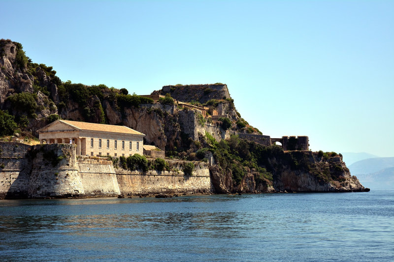
 Corfu is a Greek island in the Ionian Sea. It is the second largest island of the Ionian Islands. According to Strabo, Corcyra was the Homeric island of Scheria and its earliest inhabitants were the Phaeacians. The island has indeed been identified by some scholars with Scheria, the island of the Phaeacians described in Homer's Odyssey, though conclusive and irrefutable evidence for this theory or for Ithaca's location have not been found. At a date no doubt before the foundation of Syracuse, Corfu was peopled by settlers from Corinth, probably 730 BC, but it appears to have previously received a stream of emigrants from Eretria. The commercially advantageous location of Corcyra on the way between Greece and Magna Grecia, and its fertile lowlands in the southern section of the island favoured its growth and, influenced perhaps by the presence of non-Corinthian settlers, its people, quite contrary to the usual practice of Corinthian colonies, maintained an independent and even hostile attitude towards the mother city. The ancient city of Corfu (Paleopoli) evolved in the archaic years between two natural harbours, the one of Alkinoos and the Ellaiko (Chalkiopoulos lake). The archaeological sites are scattered all over the peninsula of Kanoni, now a suburb of the modern city. Archeological excavations brought to light sacred groves,relics of temples, houses, workshops, baths, a public market, shipyards, works of art, every day and worship objects. In Paleopoli there is the temple of Artemis Gorgo is one of the earliest Doric temples made completely out of stone and has seventeen pillars on each long side and six on each short one. The Temple has a well-preserved, huge altar (in situ) and was built in 590-580 B.C. from porous limestone. The spectacular representation on the relief pediment of the west side is at the Archaeological Museum, since the “pediment of Gorgo” is the oldest stone pediment found in Greece. The Temple was discovered in 1822 A.D. by the British Officer Whitmore, under the supervision of the German archaeologist Dorpfeld. At the east of Paleopolis there is the Mon Repos estate. There is a late Archaic (around 500 B.C.) Doric temple with eleven one-stone pillars on each long side and six on each short one. The temple is dedicated to an unidentified deity. Moreover, there is the sanctuary of Hera Acraia. Only the foundations of the Heraion are preserved. It should be mentioned that the Mon Repos estate is a neoclassical building at the east of Paleopolis and was built by the British Commissioner Sir Frederick Adams in 1830. It was latterly used by the former royal family as a summer residence and it was the birth place for Prince Philip, Duke of Edinburgh. Mon Repos estate is not an ancient monument but is located within the area of ancient Corfu and in addition now houses the museum of Paleopolis. In Paleopoli one of the towers of the fortification of the ancient city (5th-4th century B.C.) is preserved. It was later incorporated into the Church of Virgin Mary of Neratzicha. Parts of the town fortification from the 5th century B.C. have also been discovered in the “Ellaiko” harbour. In Chalkiopoulos lake there are parts of the port facilities at the “ Ellaiko” harbour of the ancient city as well as at the harbor of Alkinoos (7th-1st century B.C.), which was used as a place to keep ships in winter.  In Paleopoli one can see one of the towers of the fortification of the port of the ancient city, known as "Port of Alkinoos." It was discovered in the foundations of the church of Ag. Athanasios, built in the 18th century. The Corfu Archaeological museum is located in Garitsa near the seaside boulevard in the street of Armeni Braila. Built in the 60s under the standards followed then for buildings intended to be Museums and started its operation at September of 1967. It is the larger of Corfu museums, a two floor building with a courtyard garden and a balcony at the south and east side of the first floor. The vast bulk of the exhibits are located on the first floor which comprises by four rooms and a hallway. The largest western hall along with other artefacts from ancient temples of Palaiopolis is the pediment of the Temple of Artemis in 580 B.C. with gigantic dimensions, 17 meters width and 3 meters height and its central theme is the mythical monstrous Gorgon.
Major exhibits are the archaic funerary lion of Menekratis (late 7th century bc) found in the circular cenotaph of Menekratis, the left side of an archaic pediment (the pediment of Dionysus 500 BC) with dimensions of 2.73 meters long and about 1 meter in height that was found in Figareto and depicts of a Dionysiac banquet scene, the bronze statuette of a young “komastos” (570 BC) who runs and on his left hand holds a “rhyton”, the head of a kouros of 6th century b.c which was found in excavations of Paleopolis in Mon Repos, a clay statuette of Artemis (490 BC) found in Kanoni, the kouros of Corfu (530 BC) from Parian marble headstone and the Arniada (630-600 BC) found in the ancient cemetery near Garitsa. In the museum there are finds of Palaeolithic and Early Bronze Age as well as recent articles of the Hellenistic and Roman period. The home of our National poet Dionisios Solomos in the third end of Arseniou street at Mouragia has been turned into a museum. It is the place where the Poet lived for 30 years and inspired his poems. It presents furniture, personal items, photographs and historical material from his life. In Benitses there is the Corfu shell museum with one of Europe’s largest collection of shells and other marine species. This museum is unique not only because it is one of the few of its kind in Greece but also because the rich collection consists of very rare and beautiful marine species, some of which claim Guinness awards due to their rarity and beauty. Created by the diver and collector Napoleon Sagias, who enriched the museum with rare findings collected during his 20 years travelling in the Indian and Pacific Oceans, diving and collecting shells. The Folklore museum in Acharavi is housed in two rooms of a building situated just opposite the ancient Roman baths in the seaside village of Acharavi in centre northern Corfu. In the museum there is an interesting collection of folklore items mainly from the region of northern Corfu, objects mainly household as furniture, a loom, a traditional mill for kitchen utensils and agricultural tools of past centuries, a watermill, church supplies and other items showing the historical evolution of Corfu since then.  The ancient sources call Leucas a Corinthian colony, perhaps with a Corcyraen participation. Lefkada is a Greek island in the Ionian Sea on the west coast of Greece, connected to the mainland by a long causeway and floating bridge. Some scholars suggest that Lefkada was Homer's Ithaca, and the palace of Odysseus was located west of Nydri on the south coast of the island. The area of Apollonia's municipality had been inhabited at the very early days, as this is proved by some limited findings of Paleolithic and Neolithic period (3.500 BC) which were discovered from the excavations of the archaeologist Wilhelm Dorpfeld. In the valley of Vassiliki, the Archaelogical Service has discovered ancient archaeological ruins (ruins of towers), which probably belong to an ancient town and to the places of Marmara, Pyrgi, Klismatia, Marantochori. To the Cape of Doukato or Lefkata construction ruins and architectural parts Apollo Lefkata’s temple are located. This sanctuary was widely famous in the ancient world. Every year, Hellenic festivals have been taking place to the honour of Apollo, who was the protector of the marines and the doctor of body and soul. For this reason, ancients believed that, if you jump off the rocks, your soul would get free from the weight of passions and sins. In this place, the female poet Sappho allegedly leapt to her death from the 30 meters high cliffs. There is also an ancient wall and ruins of the ancient city “Nirikos”. Two km outside and east of the town, passing through the olive grove, one can reach Kalligoni. The area has been declared an archeological site and it embodies the ruins of the surrounding settlement of Ancient Lefkada, which are dated from Archaic to Roman times, two cemeteries of the ancient town, monuments, construction ruins, like graves, farmhouses and harbor facilities composing an integral part of the protected monumental place of the ancient town abandoned around 1300. The caste of Aghia Mavra is located at the entrance of the island. It is one of the most imposing medieval buildings of Greece, representing the fortification art of this period. It was built around 1300 from a Frank leader, Ioannis Orsini, when he took Lefkada as a wedding gift for his wedding with the daughter of Epirus Bishop Nikiforos A. The castle was protecting the capital of the island, as it was the most important defensive armoring against Pirates and other enemies, from the first decade of 14th century since 1684. In 1487, it was overtaken by Turks, who built a large arch shaped bridge with 360 rooms, which crossed the lagoon from the coast to Kalkani, with pipes of a water tower. This project was destroyed by the earthquakes. Some ruins are still preserved in the lagoon. The Lefkada Archaeological Museum is housed in the cultural center of the Borough of Lefkada (A. Sikelianou & N. Svoronou street). The findings exhibited cover a period of time, beginning in the middle of the Paleolithic times (200.000 - 35.000 π.Χ.) until the later Roman times. In a separate room at the museum, the findings of German archaeologist Wilhelm Dorpfeld are exhibited. He is the one who developed the theory that Lefkada is Homer’s Ithaca. The museum exhibits tools, ceramic and copper jewellery and gems of ancient tombs, mostly from the Ancient city of Nirikos, Nydri, Hoirospilia, Evgiros and the cave in Fryni. The “Pantazis Kontomixis” Folkloric Museum of the “Orpheus” Cultural Group is housed in the old town of Lefkada. It was founded in 1937 and includes many significant and rare exhibits, a rich collection of objects from the everyday life and business of the Lefkadite people. The Folkloric Museum of Lefkadite Canvas Works” Maria koutsohero”, in Karya village is in a small private museum in Karya Village. Among the traditional exhibit the visitor may discover the life and character, the persistence, patience and genius of the Lefkadite people, living in the highlands under rough conditions and managing to create a folkloric culture. There is also the museum of Angelos Sikelianos. In the two-storied house where Angelos Sikelianos was born and lived in Lefkada, it became possible to develop the vision and the act of the poet in a jewellery museum for an intellectual of worldview, a national pioneer, a real thinker, a politically present litterateur and a great lyric poet. The island of Lefkas or Lefkada or Lefkadia, at the time of Homer was known as the Niricos, as its capital was called. According to a prevailing view, the island owes its name to the steep white cliffs on its southernmost cape. Here is where legend states the poetess Sappho took her own life because her thwarted love for Phaon. The first traces of life on the island date to 8000 years before the birth of Christ, the Palaeolithic era. The German archaeologist Wilhelm Doerpfeld, an assistant to Heinrich Schliemann who discovered Troy and Mycenae, was the one who supported the theory that Lefkada is Homer’s Ithaca. In his excavations, in Nydri, he brought to light important findings from the Copper Age (about 2000 B.C.). The ancient Nikeos of the 7th century B.C., in which Kalligion at the “Koulmos” site was discovered, was the first capital of the island and was surrounded by a large wall. A small section of it, survives today. Moreover, the island was connected with Corinth and followed by participating in all great events of the ancient era. The Ionian Islands came to the Venetians in 1293. Afterwards, in 1300, the Castle of Aghia Mavra was built, where the capital was transferred. There follows a period that Venetians and Turks succeed each other, until 1503, when Lefkada was given with a treaty to the Turks. In 1684, was again occupied by Venetian Francis Morosini. The capital transferred out of the castle to its present location, called Amaksiki. People lost control of the harbor and trade from the Venetians. Separated from the rest of Greece and the Venetians and indifferent to develop a social and cultural background as Zakynthos and Corfu did, Lefkada struggled to create its own spiritual movement. Nevertheless, the Venetians organized public life, established courts and placed the foundations for the Administrative Services. In addition, there was an upcoming period of constant changes: • Venetian Rule: 1684 – 1797 • Democratic French: 1797 – 1798 • Russian Turks: 1798 – 1800 • Eptanisa State: 1800 – 1807 • Imperial French: 1807 – 1810 • English protection: 1810 – 1864 • Union with Greece on May 21, 1864. Lefkada and other Ionian islands become part of the Greek State. 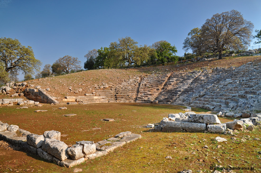 Ancient Oiniades Ancient Oiniades was one of the most important towns of ancient Akarnania. According to some historians the city was founded in 6th century BC by the Corinthians. It flourished until the Hellenistic years. The ancient city of Oiniades was built on the north shore of the Acheloos River and 4 km west of the current village of Katochi. It held a strategic position from which both the entrance to the Patraikos Gulf and the motorway between Akarnania and the islands of Lefkada, Ithaca and Kefallonia were controlled. At the same time, it was situated near the estuary of Acheloos and therefore in a position suitable for harbour construction and commercial activity. The impressive city walls are well preserved. More specifically the fortification towers over an oak-covered hill, known as the Tricarch, are dated at least since the 15th century. Its preservation is impressive and is one of the most characteristic examples of ancient fortification art. At the top of the hill is the Acropolis with a separate enclosure. The walls, about 2,60 m, with a maximum preserved height of 6 m and about 6,5 perimeter, are built along their length along the polygonal system. A separate fortification encompasses its harbor and its harbors, the so-called "fortification or acropolis of the harbour". It includes twelve gates and pillars of different types, with the most remarkable type of gate. As for the towers, others were built in the polygonal system and others in the pseudo-isodomous table-shaped structure. This element of the coexistence of a polygonal wall with towers of polygonal and pseudo-isodomous bank-shaped walls is found in most of the fortifications of Akarnania. Within the fortification, the public buildings of the Agora (boulevard, gallery, building with houses, temple, Hero) are now visible, which have been investigated in recent years by El. Serbeti, Professor of the University of Athens, the so-called "Building on the Hill", excavated by the American archaeologist B. Powell at the beginning of the last century (1900-1901), the bath of the end of the Hellenistic period, as well as the theatre. Outside the walls, graves have been excavated from the eastern cemetery of the city. The only monument of the area and one of the most imposing of antiquity, due to its very good preservation, are the jungles or the shipyards. The junipers are located at the southwest end of the fortification of the harbour, dominated by the Red Tower, a preserved 10,90 m., And the oblique arched gate, the so-called "gates" (central photography), and the ruins of a second large size and oblique to the tower top that protects it. Furthermore, there is a large ancient theatre. The construction of it is dated in three periods. First, in the 4th century, was first built by the Athenians who occupied the city. Then, in the 3rd century, repairs were made, possibly by Macedonian Philip II. Later, 167 B.C. the Romans occupy the city and engage in small-scale modifications, which are not visible today. It is a good theatre, carved into the porous limestone rock of the slope. Unfortunately, the deterioration of the rock over the centuries has destroyed part of the pitches. It is considered to be a relatively large theatre, with 23 series of seats. Some stones in the lower row of seats have inscribed inscriptions with an ancient Greek script that has been read. The orchestra is particularly large with a radius as the outer circumference of the plates with 7,65 m. The scene behind the scenes formed a front of 27,70 m. Segments of shelves found around it are Ionic. The scene as it appeared was not elevated but terrestrial and thus provides a perfect view of the orchestra. The Theatre of Oiniades is built near the Agora in a position that offers stunning views of the surrounding lowlands, the old Acheloos river bed and the coastal areas. The existence of the theatre confirms the acme of this city. The hollow of the theatre, carved in the gray local limestone of the area, is larger than a semicircle and consists of twenty-seven rows of seats, of which only ten are preserved (initially it should have been twenty-nine or thirty). The viewers approached their positions through twelve climbs (now only nine are visible), dividing the hollow into eleven non-friezes. The theatre has very good acoustics and capacity that touches 5.500 viewers. The theatre recognises two building phases, mainly related to reconstructions of the stage building. The shipyard is a special monument of the area and one of the most imposing of antiquity because of its very good preservation. Shipyards were destined to haul the ships inside, repair and stay for a certain amount of winter. The junipers are located at the southwest end of the fortification of the harbour, dominated by the Red Tower, the 10,90 m., And the oblique arched gate, the so-called "gates", as well as the ruins of a second, also large and oblique in tower tower that protects it. It is a roofed building with a plan view of the 41 m. X 47 m., whose eastern side, about 11 m. Approx., Is almost entirely carved vertically on the natural rock. On the natural rock is also carved the floor. The interior of the building divided symmetrically five columns of seventeen stranded columns. The openings between the colonnades covered the long, elongated roofs with laconic tile. Between the colonnades six sixteenth "aisles" were developed with carved horseshoes and uphill to the depths of the newcomer floors. It is for the ramps in which the ships were dragged into the halls. On the eastern side of the monument there were eleven altogether rectangular pseudo-projections (about 7 m.), which formed twelve chambers, carved vertically on the rock. The piles were used to support, anchor and seal the roof of the monument on this side. The monument, dating back to the 4 century BC, has many architectural elements related to the jetties of Zea's harbour in Piraeus.  Attractions Peloponnese is a beloved region in the south of Greece, which used to be a peninsula connected to the rest of Greece by the Isthmus of Corinth, in ancient times. Nowadays, the region is separated from the mainland by the narrow Corinth Canal, although there are many bridges connecting Peloponnese to Attica across the canal. It is a highly cultural and popular area, being celebrated by many tourists from all over the world, especially during the summer season. In Peloponnese there are many natural beauties, such as mountains, forests, rivers and caves, surrounded by the sea and sandy beaches completed by monuments from every period of the eventful Peloponnesian history, breathtaking archaeological sites and gorgeous Byzantine churches making the Peloponnese region a highly sought-after holiday destination. Peloponnese has a dry climate on the east, cold, snow and rich vegetation in its central and mountainous parts and rain and heat on the west.

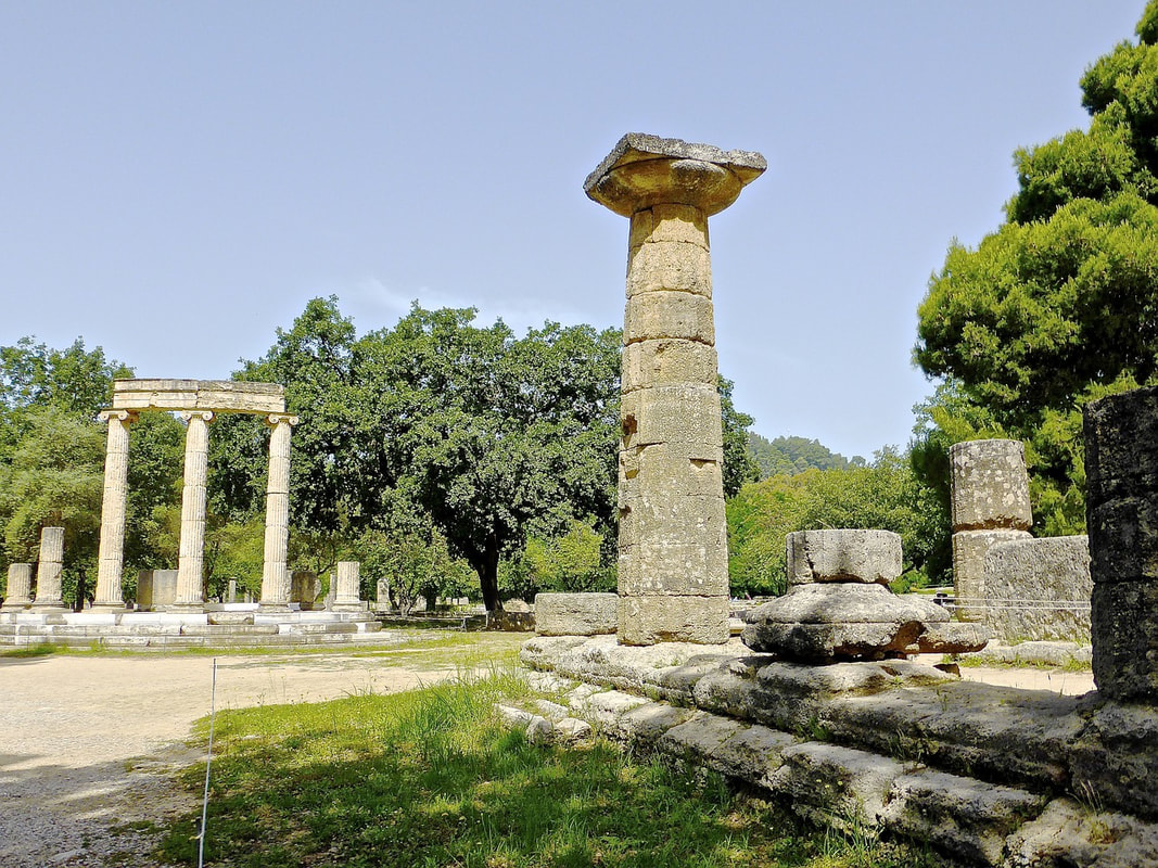 Attractions in Olympia
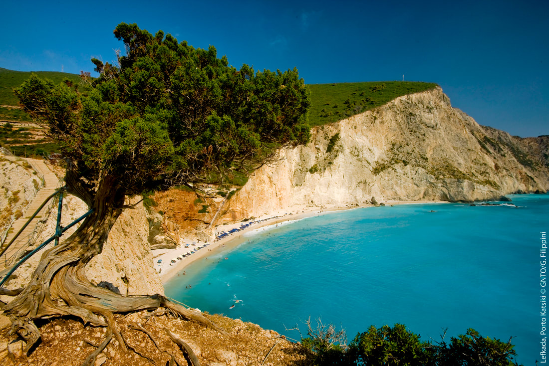
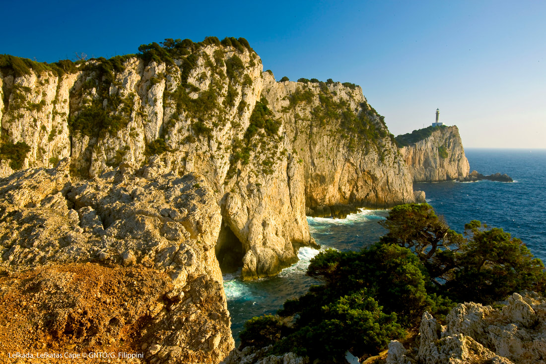
7 day itinerary - On the Lefkas Round
Lefkada is a Greek island in the Ionian Sea on the west coast of Greece, connected to the mainland by a long causeway and floating bridge. Some scholars suggest that Lefkada was Homer's Ithaca, and the palace of Odysseus was located west of Nydri on the south coast of the island. The area of Apollonia's municipality had been inhabited at the very early days, as this is proved by some limited findings of Paleolithic and Neolithic period (3.500 BC) which were discovered from the excavations of the archaeologist Wilhelm Dorpfeld. In the valley of Vassiliki, the Archaelogical Service has discovered ancient archaeological ruins (ruins of towers), which probably belong to an ancient town and to the places of Marmara, Pyrgi, Klismatia, Marantochori. To the Cape of Doukato or Lefkata construction ruins and architectural parts Apollo Lefkata’s temple are located. This sanctuary was widely famous in the ancient world.
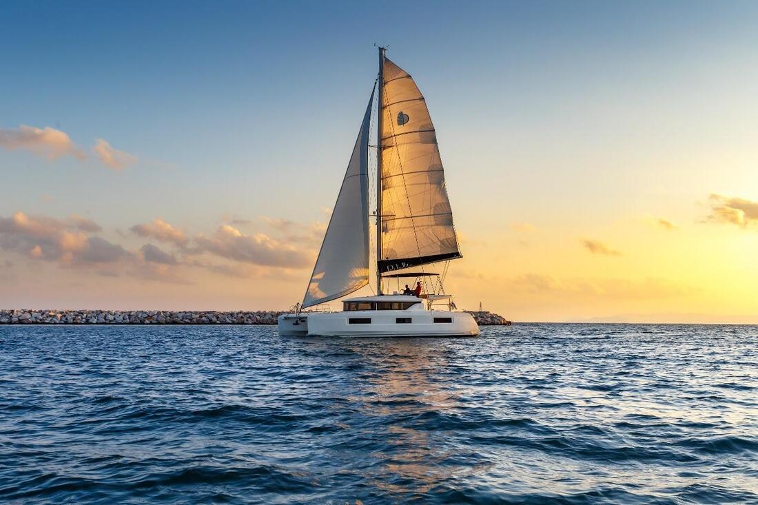
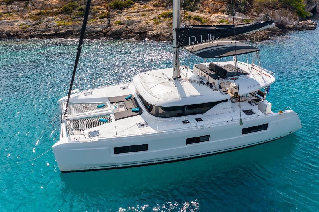
Discover Our Fleet: Explore More About Our Sailing Program.
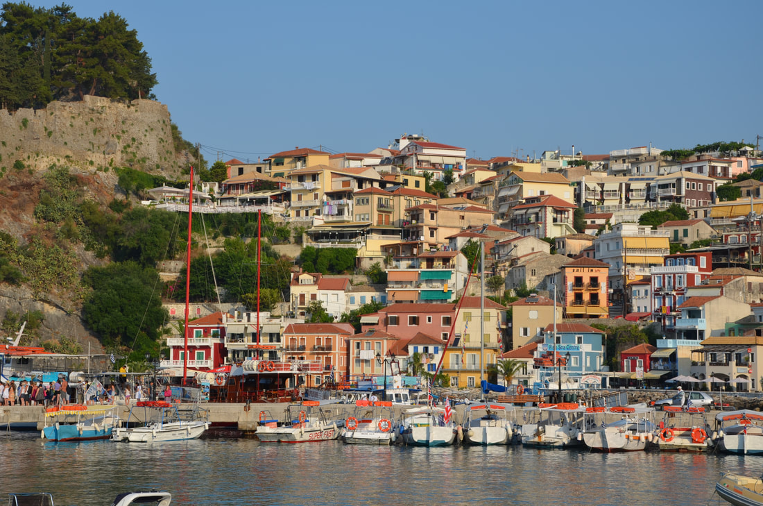
DAY 1 - LEFKADA TOWN
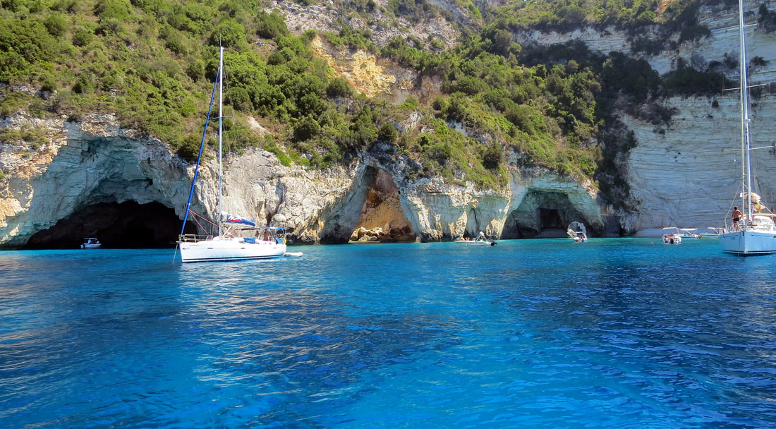
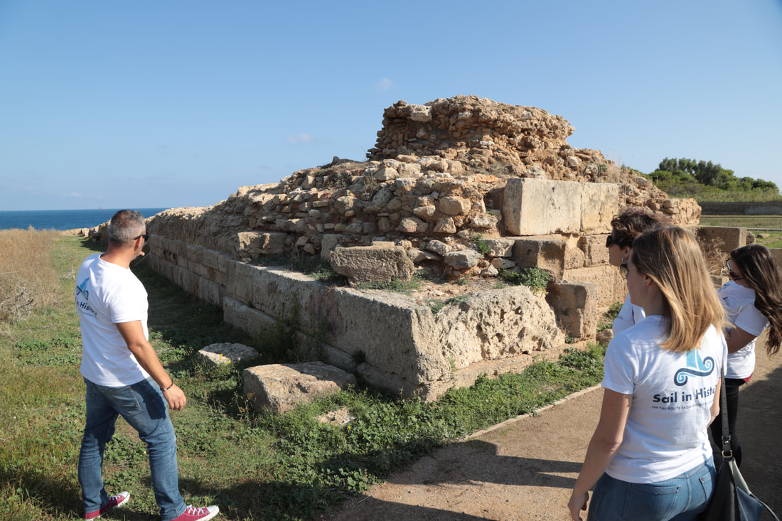
Welcome to the beautiful island of Lefkada! Get ready to explore its charming capital, Lefkada Town. Begin your day with a sightseeing tour of the town and immerse yourself in the local culture. After that, join us for a briefing and video presentation about the island of Lefkada and the route of our cruise. Next, we'll visit the archaeological museum of Lefkada and learn about the fascinating history of the island. After working up an appetite, enjoy a delicious lunch at a local restaurant. In the afternoon, we'll check-in and settle into our accommodations on board the ship. Join us for a welcome meeting on the boat where we'll present the general project and cruise plan. As the day comes to an end, enjoy a mouthwatering dinner with a sea view and experience the vibrant nightlife of the island. DAY 2 - MEGANISI - VATHI Wake up to the sound of waves and the beautiful sunrise over Lefkada. Today, we'll sail to Steno Nydri and then continue our journey to the legendary Scorpios Island, where you'll have the opportunity to take a refreshing dive in the crystal-clear waters. After working up an appetite, indulge in a scrumptious lunch on board. We'll then set sail for Meganisi island, where we'll spend the evening in the picturesque port of Vathi. Enjoy a delicious dinner and take in the beautiful scenery before returning to the boat. DAY 3 - BEACH DAY Today, we'll head to one of the most beautiful beaches in Greece, Agiofylli. We'll make a few stops along the way for swimming and other activities. After working up an appetite, join us for lunch on board. In the afternoon, we'll watch a video about pottery and discuss the following activity. Get creative and try your hand at pottery-making! Afterward, we'll set sail for Sivota and watch a video about ancient Greek food. Get ready to experience a unique dinner on board, inspired by the flavors of Ancient Greece, including a wine tasting experience. DAY 4 - KEFALONIA ISLAND Today, we'll sail to the nearby beaches of Kefalonia island, stopping along the way for a refreshing swim. After working up an appetite, enjoy a mouthwatering lunch on board and take a well-deserved rest. In the evening, we'll arrive in the port of Fiscardo and explore the town's charming sights. Take some time to explore the local shops, bars, and restaurants. Enjoy a night out and spend the night on board the boat. DAY 5 - KEFALONIA & ITHACA ISLAND Today, we'll focus on environmental awareness and sustainability. We'll sail from Fiscardo to Aetos Alalkomenes for a Microplastics activity. Afterward, we'll visit the magnificent Melissani Cave and take a refreshing dive in its crystal-clear waters. Enjoy a delicious lunch on board and indulge in an olive oil tasting experience. We'll then set sail for the stunning island of Ithaca, where we'll enjoy dinner in a seaside tavern. Spend the night on board the boat. DAY 6 - ANCIENT OINIADES After breakfast on board, the boat will set sail from Vathi towards Astakos. From there, you will take a drive to the ancient site of Oiniades. This archaeological site is a hidden gem of Greece and is relatively less visited, but it has an immense historical significance. You will have the opportunity to explore the ruins of this ancient city, which was founded in the 6th century BC and was an important center of commerce during the classical period. After the visit, you will head to a small, picturesque tavern where you will have lunch and enjoy some traditional Greek dishes. You can also take some time to relax and soak in the stunning surroundings. In the afternoon, you will return to Astakos, where you can take some time to explore the town and its charming surroundings. In the evening, you will have dinner at a local restaurant, where you can savor some delicious Greek food and enjoy a night out. You will then spend the night on board. DAY 7 - RETURN TO LEFKADA After breakfast on board, you will set sail from Astakos back to the island of Lefkada. On the way, you will stop at a beautiful spot for a swim and to enjoy the crystal-clear waters of the Ionian Sea. You can also take some time to relax on the boat and soak in the stunning surroundings. You will then have lunch on board before arriving back in Lefkada, where your journey began. This will be your last chance to enjoy the beauty of this magical island and to say goodbye to your fellow travelers and crew. In the evening, you will have a final discussion of the trip and fill out an evaluation form to share your feedback. You can also take some time to exchange contact information with your fellow travelers and crew members. Overall, this itinerary is designed to give you an unforgettable experience of the Ionian Islands. You will have the opportunity to explore some of the most beautiful and historically significant sites in the region, sample delicious Greek cuisine, and soak in the natural beauty of this stunning archipelago.
Highlights:
1. Sightseeing of Lefkada Town 2. Visit to the Archaeological Museum of Lefkada 4. Accommodation on board and welcome meeting 5. Dinner at a restaurant with a sea view and night out in Lefkada Town 6. Sailing to Steno Nydri and Scorpios Island, stopping for a dive 7. Lunch on board and departure to Meganisi island 8. Dinner in the port of Vathi, Meganisi 9. Departure for Agiofylli beach and swimming stops 10. Video about pottery and discussion of the following activity - Pottery activity 11. Departure for Sivota and video about ancient Greek food, discussion of the following activity - Dinner on board with ancient Greek food and wine tasting 12. Departure from Sivota to nearby beaches of Kefalonia Island, small stops for a swim until lunch 13. Lunch on board and rest 14. Sightseeing of the port of Fiscardo, Kefalonia Island and night out 15. Sailing from Fiscardo to Aetos Alalkomenes, Microplastics activity 16. Visit to Melissani Cave and stop for a dive 17. Lunch on board and olive oil tasting experience 18. Departure from Melissani Cave to Sami and sightseeing in the town 19. Sailing from Sami to the island of Ithaca and dinner in a tavern with a sea view 20. Departure from Vathi to Astakos 21. Driving from Astakos to the archaeological site of Ancient Oiniades 22. Visiting the archaeological site of Ancient Oiniades and lunch in a small, picturesque tavern 23. Dinner in the port of Astakos and night out 24. Final sailing from Astakos back to the island of Lefkada with a stop for a swim 25. Final discussion of the trip and evaluation form 
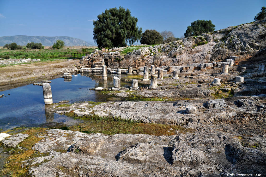
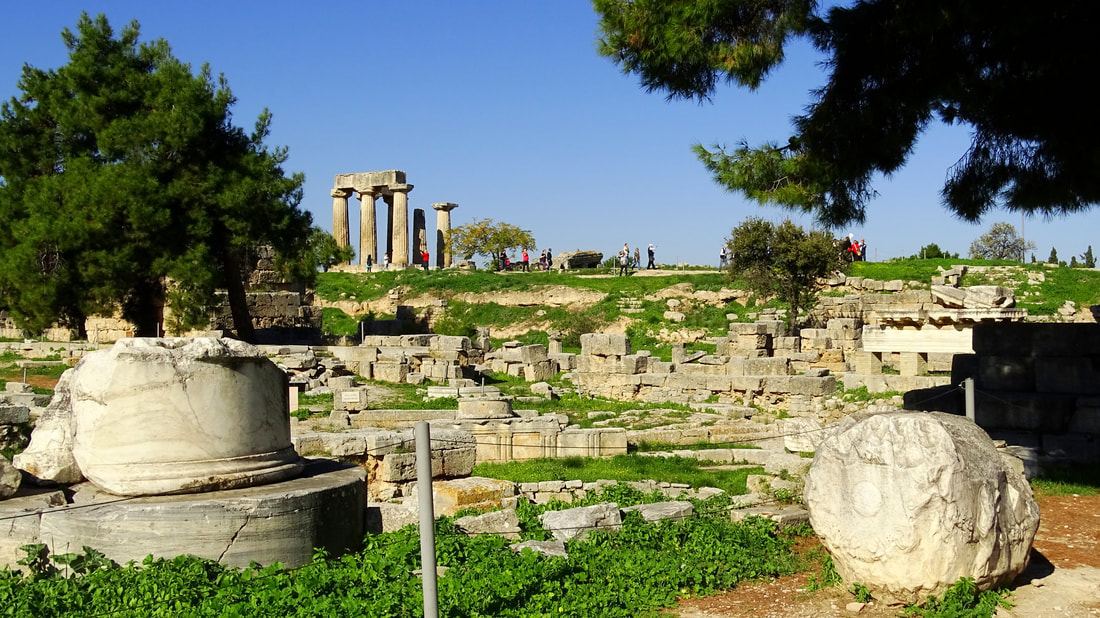 Ancient Corinth was one of the most important city-states of ancient Greece. Today in the archaeological site, one can visit the Temple of Apollo; its seven remaining Doric columns stand in a prominent position overlooking the ancient Agora. The temple was built in 530 BC, consisting of 2 rooms, and originally had 15 Doric-order columns along its length and 6 along its width. The city market had a rectangular shape, housing a number of similarly laid-out stores, each divided into 2 rooms. Its front was consisted by a double row of columns, the outer Doric and inner Ionic. In the ancient Agora, one can also visit the shops where the Apostle Paul once stood, along with the ancient Council. Descending the steps of the ‘propylaia’ (front gates) will lead you to Lecheou street where you will encounter the Pirene Fountain, with its six cave-like chambers, and the Glauki fountain standing carved in the rock. In the archaeological site you will also have the chance to visit the Odeon, built in the 1st century AD; and the 18,000-seat theater built in the fifth century BC, and later converted by the Romans into an arena for animal fights. Finally, you can walk through the remnants of the gymnasium and Temple of Asclepius near the Lerna fountain. Above Ancient Corinth lies the Castle of Akrocorinth, the Acropolis of the ancient city, which is itself worth a visit. Places of interest near Corinth Itea (Greek: Ιτέα meaning willow), is a town and a former municipality in the southeastern part of Phocis, Greece. Built in the background of the Crissaean Gulf extends together with the neighbouring Kirra, along the coastline of the plain sharing the same name, the Crissaean Plain and it is the south ending up of the famous landscape of Delphi. It is a relatively new city, since it was founded in 1830 and it managed to become soon an important commercial and transit centre due to a series of favourable circumstances. The access to the city is easy, either by sea - it has a good port that serves the transport of both people and goods - or by land, as it is connected to the big road axis of Greece. It constitutes the way out to the sea not only for the Department - it is the port of Amfissa and Delphi - but also for the entire area of Central Greece. Galaxidi or Galaxeidi is a town and a former municipality in the southern part of Phocis. Modern Galaxidi is built on the site of ancient Haleion, a city of western Locris. Traces of habitation are discernible since prehistoric times with a peak in the Early Helladic Period (Anemokambi, Pelekaris, Kefalari, islet of Apsifia). A significant Mycenaean settlement has been located at Villa; the hill of St. Athanasios also revealed a fortified Geometric settlement (ca. 700 BC). In the Archaic and Classical periods (7th-4th centuries BC) was developed the administrative and religious centre at the modern site of Agios Vlasis. It seems that in ca. 300 BC the present site was settled and surrounded by a fortification wall; it is the period of the expansion of power of the Aetolian League. Haleion flourished throughout the Hellenistic and Roman periods until the 2nd century AD. In an old mansion of Galaxidi are situated two museums: The Archaeological Collection of Galaxidi presents a collection, which was established in 1932 to host antiquities found and donated by citizens as well as excavation finds from the regions in and around Galaxeidi. The exhibition is organised in three main themes: (a) Private and daily life, (b) Trade and maritime activity and (c) Cemeteries. It focuses on the educational aspects as the finds are accompanied by pictures and texts, revealing the history of ancient Haleion, the precursor of Galaxeidi. The Maritime Museum of Galaxidi includes the Chronicle of Galaxidi, which was published by Konstantinos Sathas in 1865. It used to serve as a town hall for Galaxidi. The Chronicle of Galaxeidi is a Greek chronicle written in the year 1703 detailing the history of the town of Galaxeidi on the northern shore of the Gulf of Corinth and its wider region, including the towns of Naupaktos, Amfissa, and Loidoriki, from the Middle Ages to 1690. History Corinth’s settlement dates to 5000 B.C. which was discovered in the Korakos region, a testament to Corinthos’ habitation since the Neolithic Age. In antiquity, Korinthos was one of the largest and most important cities in Greece which had a key-role during the Peloponnesian War. After 200 B.C. became the capital of the Achaean Confederation. Under Julius Caesar it was elevated to the capital of the Achaia province. During the middle Ages it was associated with its impressive fortifications at Akrokorinthos (Acrocorinth). A powerful earthquake destroyed the city in 1858, which was rebuilt with earthquake resistant specifications undera new town plan, 9 km to the north of the ancient city. The town of Palaia Corinthos is situated on the site of Ancient Corinthos. Today, Corinth is located about 83 km west of Athens. The Municipality of Corinth had a population of 58,192, according to the 2011 census, the second most populous municipality in the Peloponnese Region, after Kalamata. It is surrounded by the coastal townlets of Lechaio, Isthmia, Kechries, and the inland townlet of Examilia and the archaeological site and village of ancient Corinth. Natural features around the city include the narrow coastal plain of Vocha, the Corinthian Gulf, the Isthmus of Corinth cut by its canal, the Saronic Gulf, the Oneia Mountains and the monolithic rock of Acrocorinth, where the medieval acropolis was built. Capital’s prefecture is the region’s prominent administrative, commercial, financial and cultural center. The city center has wide roads, parks, squares and a picturesque port with fishing boats. Beautiful pedestrian walkways entice the visitors for a stroll, coffee and shopping, with monuments, museums and historical sites surrounding the city. 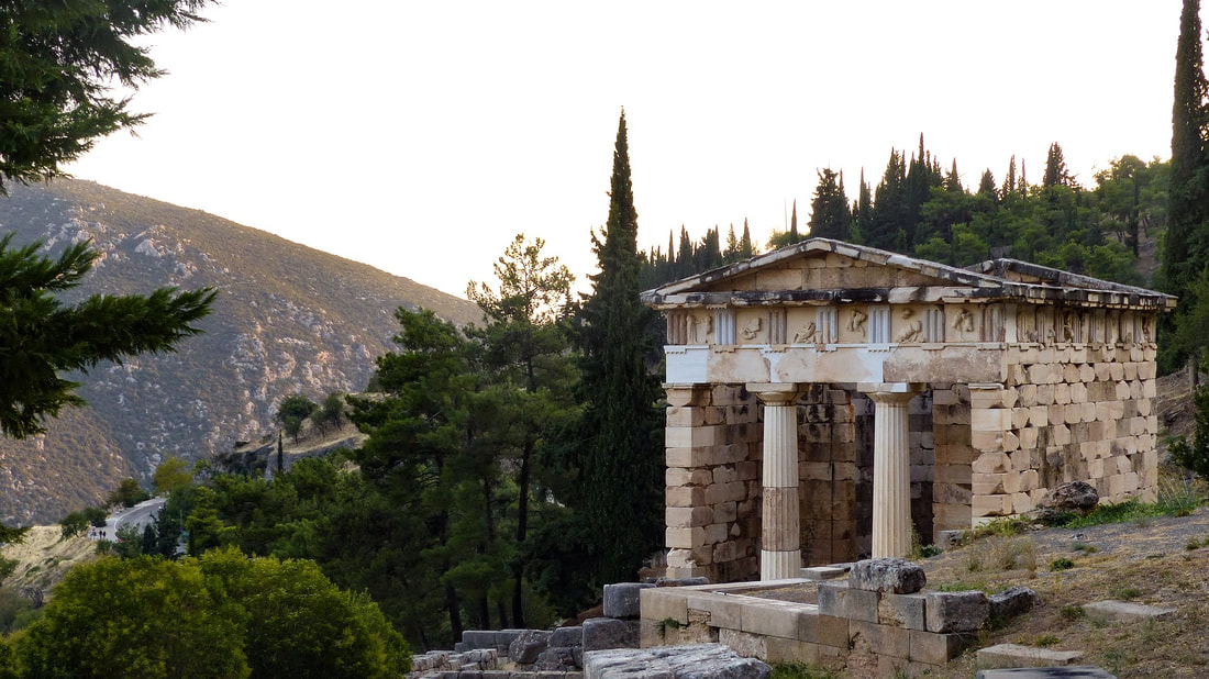 Delphi Delphi was a most known religious and cultural place in antiquity, being a Panhellenic temenos and a famous oracle in ancient Greece. It is indicative how both the myths and ancient sources refer to Delphi as the center of the world, lying at the foot of Mount Parnassos in a spectacular landscape with an overview of the Itea Bay. The archaeological site includes two sanctuaries dedicated to Apollo and Athena Pronaia. Apollo was the main deity worshiped in Delphi and his cult was established in the eighth century BC almost simultaneously to the first building activity in the sanctuary. The myths refer to the foundation of the sanctuary by Apollo, when he arrived transformed into a dolphin and call him Delphinios. Another myth reports Apollo Pythios to have killed the serpent Python that guarded the original temenos of Mother Earth; the famed Pythian Games celebrated this death and honored Apollo with musical and athletic festivities. By the sixth century BC the Pythian festival had become almost as popular as the famed Olympic Games, following the growing religious influence of Delphi throughout Greece. The music contests took place at the theatre, which was first built in stone in the fourth century BC and was subsequently refurbished several times. Its present form dated to the third century BC could host around five thousand people. In 582 BC athletic events, almost similar to the Olympic ones, were also included to the Pythian Games. Since the fifth century BC they took place at the stadium, which was higher up the slope and is well preserved nowadays in the form it was built in the second century BC. The names of the winners on the bases of their statues, as reported by Pausanias, prove the Panhellenic participation in these Games. Supporting this, the Pindar’s Odes praise the Pythic winners and more particularly, the chariot race winner Iero, tyrant of the Sicilian city of Gela. Polyzalos, also a tyrant of Gela dedicated to Apollo the famous bronze statue of a Charioteer after his victory at a chariot race of the Pythian Games. Another wealthy votive offering was that of Daochos II. It consisted of nine marble statues, all members of Daochos’ family who were winners at the games in Delphi. Both statues are on display in the Delphi Archaeological Museum of Delphi. Delphi was regarded in antiquity as the most trustworthy oracle and both ordinary people or prestigious rulers and cities consulted it. The divination and other cult rituals took place in the temple of Apollo and more particularly in the adyton, where also a statue of Apollo and the omphalos, symbol of Delphi as the center of the world, were housed. According to the legend, there were five different temples of Apollo built before the existing one, an imposing Doric temple completed in 330BC and nowadays standing on a central terrace and partially restored. The oracle grew in fame especially during the archaic colonization, when the Greek metropoleis seeked for approve of the God before founding a colony, enhancing the religious ties between the cities. It is indicative of its political power the fact that the Oracle continued to monitor the colonies after their establishment. In the course of the seventh century the oracle’s fame reached from Magna Graecia to the west to Minor Asia to the east. The Oracle reached its peak between the sixth and the fourth centuries BC, when numerous votive offerings from around the Greek world were dedicated to Apollo as a sign of gratitude for his guidance or in occasion of important events, such as war victories or wins at the Pythic Games. Most votive offerings stood along the so-called Sacred Way, a road that pilgrims and visitors followed through the temenos until they reached the temple of Apollo. Amongst others stand out the Treasuries, small buildings in the shape of a temple, built by cities in order to safe keep their offerings and display their wealth and prosperity to the visitors of the sanctuary. There were several Treasuries in the sanctuary reported by sources, including the earliest one dedicated by the Corinthians, and the Treasury of the Massaliots, built in order to enhance the increasing commercial power of this colony. As in both these situations, not all the treasuries have been identified in the ruins with certainty or are clearly visible. One of the wealthiest monuments in the sanctuary was the treasury dedicated by the people of Siphnos, the most prosperous of the Greek islands in the sixth century BC. It was made of Parian marble and had an admirable relief decoration. Although the Treasury is only preserved on the foundations level, its sculptures are on display in the Archaeological Museum of Delphi. The most dominant Treasury along the Sacred Way is that of the Athenians, built around 500 BC as a symbol of the victory of democracy over tyranny or in memory of the victory of the Athenians against the Persians in Marathon (490 BC). It had the shape of a small Doric temple in antis and according to literary sources, it contained trophies of several Athenian war victories including the battle of Marathon. It was restored so that nowadays it stands out at the archaeological site. It was famous for its elegant relief decoration with mythical scenes of the Greek heroes Theseus and Hercules; the original sculptures are on display in the Archaeological Museum of Delphi. The archaeological site of Delphi also includes a sanctuary dedicated to Athena Pronaia. Within its boundaries among altars and several cult buildings, there were the famous circular Tholos and the remains of three temples dedicated to the goddess, two archaic ones and one dated in the fourth century BC. There has been archaeological research in Delphi since the 19th century in both sanctuaries. The Archaeological Museum situated at the site presents their history by displaying the finds in thematic units.  Olympia
A sanctuary of ancient Greece in Elis on the Peloponnese peninsula, is known for having been the site of the Olympic Games in classical times. The most celebrated sanctuary of ancient Greece lies in the beautiful valley of the Alpheios river. Dedicated to Zeus, the father of the gods, it sprawls over the southwest foot of Mount Kronios, at the confluence of the Alpheios and the Kladeos rivers, in a lush, green landscape. Although secluded near the west coast of the Peloponnese, Olympia became the most important religious and athletic centre in Greece. Its fame rests upon the Olympic Games, the greatest national festival and a highly prestigious one world-wide, which was held every four years to honour Zeus. The origin of the cult and of the festival went back many centuries. Local myths concerning the famous Pelops, the first ruler of the region, and the river Alpheios, betray the close ties between the sanctuary and both the East and West. Remains of food and burnt offerings dating back to the 10th century BC give evidence of a long history of religious activity at the site. No buildings have survived from this earliest period of use. The first Olympic festival was organised on the site by the authorities of Elis in the 8th century BC – with tradition dating the first games at 776 BC. The classical period, between the 5th and 4th centuries BC, was the golden age of the site at Olympia. A wide range of new religious and secular buildings and structures were constructed. During the Roman period, the games were opened up to all citizens of the Roman Empire. The 3rd century saw the site suffer heavy damage from a series of earthquakes. Invading tribes in 267 AD led to the centre of the site being fortified with material robbed from its monuments. Despite the destruction, the Olympic festival continued to be held at the site until the last Olympiad in 393 AD, after which the Christian emperor Theodosius I implemented a ban. The archaeological site is located withing walking distance of the modern village called Ancient Olympia and it includes ruins from Bronze Age to the Byzantine eras. The site covers an expanded area of ruins scattered among low trees, as well as the ancient stadium where the Olympics took place. An impressive array of artefacts, which were unearthed during excavations, is an exhibition at the nearby Olympia Museum.  The city hosts the National Museum of Magna Graecia, housing an archaeological collection from sites in Magna Graecia. In this structure there are exposed various objects from excavation campaigns in the ancient city-states of Calabria, Basilicata and Sicily, including the Riace Bronzes, one of the symbols of Magna Graecia. They are extremely important for studies of the 8th century BC, but also have several objects from the prehistoric and protohistoric periods, which preceded it and the following ancient Roman and Byzantine eras. Reggio Calabria is a city of art and science, jealous of the inheritance of its glorious past but outstretched towards a future of development and progress. The National Archaeological Museum preserves magnificent and ancient memories of the prehistoric, Greek and Roman eras, and the vigorous Riace warriors seem to defend such a great richness. Museum hosts also a section dedicated to underwater archaeology, which has opened their first display area with information panels explaining and detailing the ancient maritime routes along the Calabrian coast. A collection of anchors in lead and of vases, from various locations and dates, demonstrates the navigational patterns in this area for the whole of the Greek and Roman period. A glass display case exhibits relics recovered from a naval wreck (dating from the end of the 5th century BC) located in 1969 near the port of Villa San Giovanni: the objects found are articles of everyday use (fishing equipment and crockery) along with globe vases, which may have contained ink (probably for commercial exchange). In the adjacent case relics found at Riace Marina (1972 – 1973) are displayed, from the sea bed where the “Bronzi” were recovered: 28 lead rings belonging to the sails of an ancient ship, a fragment of keel which has been identified as being from Roman or Byzantine period, the handle of the shield held by “Bronzo A”, and the lead tethers which held the statue’s feet to its base. Today new finds in Calabria are no longer displayed and conserved in a single museum, but exhibited where they have been found, since the quantity of new discoveries has allowed smaller local museums to be set up for them (at Crotone, Locri, Roccelletta di Borgia, Sibari, Vibo Valentia and Lamezia Terme). These are taken together as the Museo Reggino. Attractions The city of Reggio Calabria is located at the tip of the "Stivale", on the slopes of the Aspromonte Park, on the eastern shore of the Strait of Messina, from which it enjoys a spectacular view of Sicily, Mount Etna and the Aeolian Islands. Traditionally it is called Città della Fata Morgana because here the rare optical-mythological phenomenon of the Fata Morgana manifests itself, during which the Sicilian coast seems to be only a few meters away making it possible to distinguish houses, cars and people very well. To see also the Lungomare Falcomatà: considered by some "the most beautiful kilometer of Italy", the Corso Garibaldi, an animated street full of shops; the Duomo, with the baroque chapel of S.S. Sacrament; the Aragonese Castle. There are many interesting villages and tourist resorts in the province: starting from the area of the Strait, in addition to the aforementioned city of Reggio Calabria, we point out Cannitello, a holiday resort at the point nearest to Sicily, further south, in the hills, is located the Byzantine Castle of S. Niceto near Motta San Giovanni. The Aspromonte covers a large area of the territory of the entire province, and arrives, with its highest peak represented by Montalto, at an altitude of 1956 m. The most famous tourist resort is Gambarie (1300 m), equipped for winter sports and therefore equipped with slopes, ski facilities, chair lift, and various accommodation facilities. The particular uniqueness of the place is worth mentioning: it is the only ski resort in all of Europe where you can ski watching the sea, given the position overlooking the Strait of Messina. At the innermost part of the Aspromonte is the Sanctuary of the Madonna di Polsi, a destination for pilgrimages in the summer. The eastern area of the Massif is home to the Aspromonte National Park. The Costa Viola is a splendid 25 km long coastal arch that faces first on the Strait, then on the Aeolian Islands. Scilla, from the beautiful castle, is included in the circuit "The Most Beautiful Villages of Italy", offers the charm of the Chianalea fishing district, with houses directly on the sea; other places worthy of note are Bagnara, Melìa, Solano, places of breathtaking views from the mountain that falls to the sea. In the Gioia Tauro plain, the current Gioia Tauro, once Metauros, includes an interesting archaeological area and an archaic necropolis in the Pietra district. Noteworthy are the centers of Palmi, which houses the Ethnographic Museum and the Antiquarium, famous for the beaches of Tonnara and Marinella, set in the high and jagged coastline dominated by Mount St. Elias, "defined the balcony on the Strait"; Seminara, known for the traditional craftsmanship of ceramics; Rosarno, the ancient Medma, with the museum and the archaeological area; Galatro, from the picturesque old town arranged in steps and the thermal plant; San Giorgio Morgeto with its medieval historic center; Oppido Mamertina with the archaeological area and the historical center. Moving to the ionic belt of the province, further south is the Grecanica area. To be visited absolutely is Pentedattilo, a ghost town clinging to a giant cliff with the shape of five fingers reaching out to the sky; Bova Marina with the archaeological area; in the hinterland there are all the centers of the Grecanici ethnic-linguistic community: Bova, Roghudi, Chorio, Roccaforte del Greco and Gallicianò. The Grecian area is located on the south side of the Aspromonte, the territory is characterized by the rivers, including the Amendolea, which looks like a huge silver ribbon of pebbles bordered by citrus and broom plants, a very frequent destination for trekking in the summer. Towards the North-East is Palizzi, with its characteristic castle and white gullies, and the best-known resorts of the Gelsomini Riviera: Brancaleone, Bianco, famous for its "Greek" dessert wine production; and other seaside resorts.
 Delphi was a most known religious and cultural place in antiquity, being a Panhellenic temenos and a famous oracle in ancient Greece. It is indicative how both the myths and ancient sources refer to Delphi as the center of the world, lying at the foot of Mount Parnassos in a spectacular landscape with an overview of the Itea Bay. The archaeological site includes two sanctuaries dedicated to Apollo and Athena Pronaia. Apollo was the main deity worshiped in Delphi and his cult was established in the eighth century BC almost simultaneously to the first building activity in the sanctuary. The myths refer to the foundation of the sanctuary by Apollo, when he arrived transformed into a dolphin and call him Delphinios. Another myth reports Apollo Pythios to have killed the serpent Python that guarded the original temenos of Mother Earth; the famed Pythian Games celebrated this death and honored Apollo with musical and athletic festivities. By the sixth century BC the Pythian festival had become almost as popular as the famed Olympic Games, following the growing religious influence of Delphi throughout Greece. The music contests took place at the theatre, which was first built in stone in the fourth century BC and was subsequently refurbished several times. Its present form dated to the third century BC could host around five thousand people. In 582 BC athletic events, almost similar to the Olympic ones, were also included to the Pythian Games. Since the fifth century BC they took place at the stadium, which was higher up the slope and is well preserved nowadays in the form it was built in the second century BC. The names of the winners on the bases of their statues, as reported by Pausanias, prove the Panhellenic participation in these Games. Supporting this, the Pindar’s Odes praise the Pythic winners and more particularly, the chariot race winner Iero, tyrant of the Sicilian city of Gela. Polyzalos, also a tyrant of Gela dedicated to Apollo the famous bronze statue of a Charioteer after his victory at a chariot race of the Pythian Games. Another wealthy votive offering was that of Daochos II. It consisted of nine marble statues, all members of Daochos’ family who were winners at the games in Delphi. Both statues are on display in the Delphi Archaeological Museum of Delphi. Delphi was regarded in antiquity as the most trustworthy oracle and both ordinary people or prestigious rulers and cities consulted it. The divination and other cult rituals took place in the temple of Apollo and more particularly in the adyton, where also a statue of Apollo and the omphalos, symbol of Delphi as the center of the world, were housed. According to the legend, there were five different temples of Apollo built before the existing one, an imposing Doric temple completed in 330BC and nowadays standing on a central terrace and partially restored. The oracle grew in fame especially during the archaic colonization, when the Greek metropoleis seeked for approve of the God before founding a colony, enhancing the religious ties between the cities. It is indicative of its political power the fact that the Oracle continued to monitor the colonies after their establishment. In the course of the seventh century the oracle’s fame reached from Magna Graecia to the west to Minor Asia to the east. The Oracle reached its peak between the sixth and the fourth centuries BC, when numerous votive offerings from around the Greek world were dedicated to Apollo as a sign of gratitude for his guidance or in occasion of important events, such as war victories or wins at the Pythic Games. Most votive offerings stood along the so-called Sacred Way, a road that pilgrims and visitors followed through the temenos until they reached the temple of Apollo. Amongst others stand out the Treasuries, small buildings in the shape of a temple, built by cities in order to safe keep their offerings and display their wealth and prosperity to the visitors of the sanctuary. 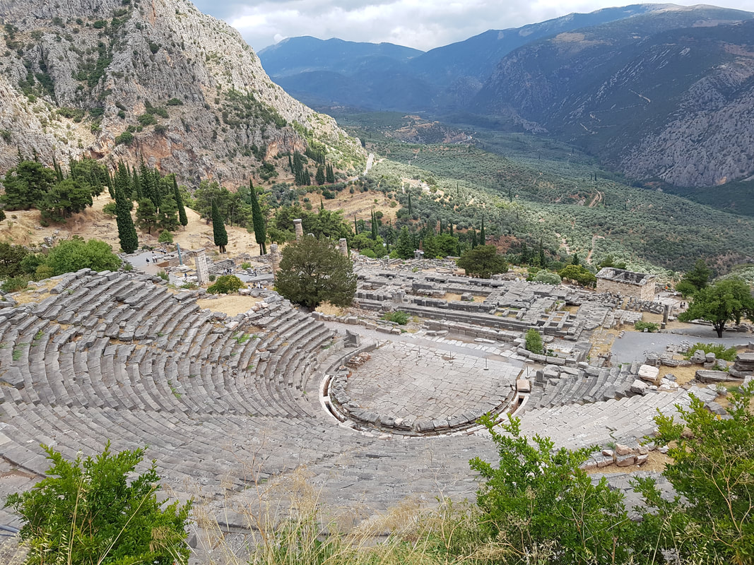 There were several Treasuries in the sanctuary reported by sources, including the earliest one dedicated by the Corinthians, and the Treasury of the Massaliots, built in order to enhance the increasing commercial power of this colony. As in both these situations, not all the treasuries have been identified in the ruins with certainty or are clearly visible. One of the wealthiest monuments in the sanctuary was the treasury dedicated by the people of Siphnos, the most prosperous of the Greek islands in the sixth century BC. It was made of Parian marble and had an admirable relief decoration. Although the Treasury is only preserved on the foundations level, its sculptures are on display in the Archaeological Museum of Delphi. The most dominant Treasury along the Sacred Way is that of the Athenians, built around 500 BC as a symbol of the victory of democracy over tyranny or in memory of the victory of the Athenians against the Persians in Marathon (490 BC). It had the shape of a small Doric temple in antis and according to literary sources, it contained trophies of several Athenian war victories including the battle of Marathon. It was restored so that nowadays it stands out at the archaeological site. It was famous for its elegant relief decoration with mythical scenes of the Greek heroes Theseus and Hercules; the original sculptures are on display in the Archaeological Museum of Delphi.
The archaeological site of Delphi also includes a sanctuary dedicated to Athena Pronaia. Within its boundaries among altars and several cult buildings, there were the famous circular Tholos and the remains of three temples dedicated to the goddess, two archaic ones and one dated in the fourth century BC. There has been archaeological research in Delphi since the 19th century in both sanctuaries. The Archaeological Museum situated at the site presents their history by displaying the finds in thematic units. 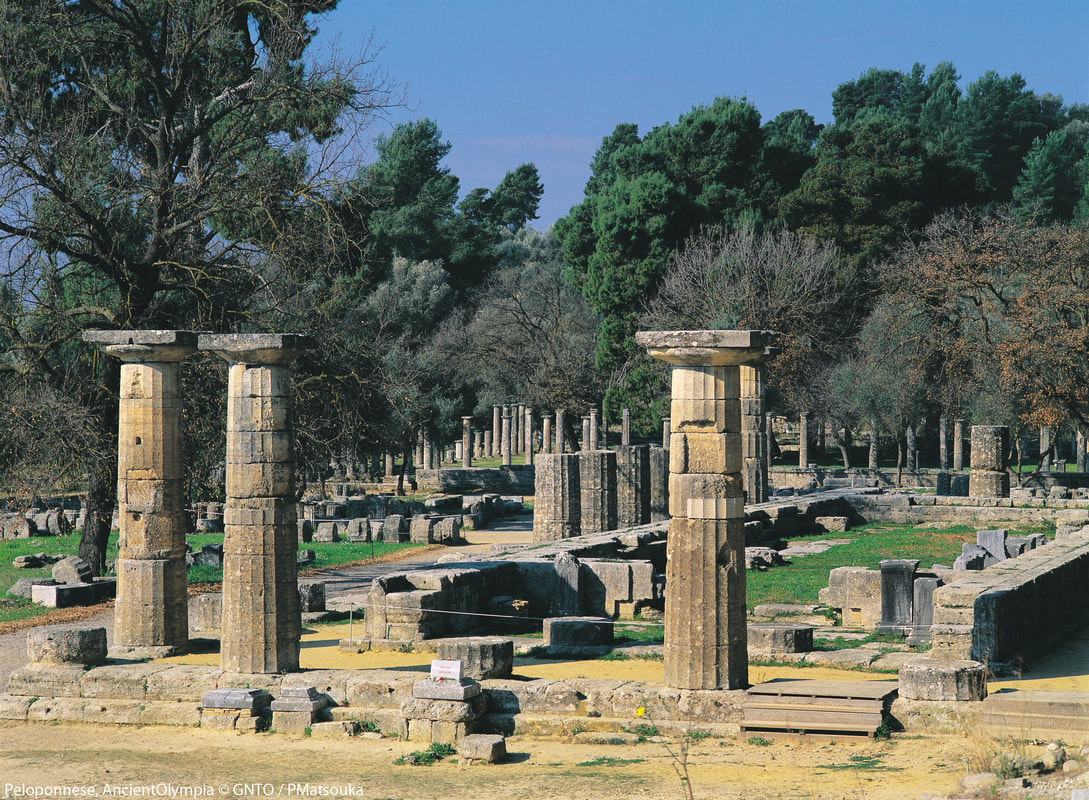 A sanctuary of ancient Greece in Elis on the Peloponnese peninsula, is known for having been the site of the Olympic Games in classical times. The most celebrated sanctuary of ancient Greece lies in the beautiful valley of the Alpheios river. Dedicated to Zeus, the father of the gods, it sprawls over the southwest foot of Mount Kronios, at the confluence of the Alpheios and the Kladeos rivers, in a lush, green landscape. Although secluded near the west coast of the Peloponnese, Olympia became the most important religious and athletic centre in Greece. Its fame rests upon the Olympic Games, the greatest national festival and a highly prestigious one world-wide, which was held every four years to honour Zeus. The origin of the cult and of the festival went back many centuries. Local myths concerning the famous Pelops, the first ruler of the region, and the river Alpheios, betray the close ties between the sanctuary and both the East and West. Remains of food and burnt offerings dating back to the 10th century BC give evidence of a long history of religious activity at the site. No buildings have survived from this earliest period of use. The first Olympic festival was organised on the site by the authorities of Elis in the 8th century BC – with tradition dating the first games at 776 BC. The classical period, between the 5th and 4th centuries BC, was the golden age of the site at Olympia. A wide range of new religious and secular buildings and structures were constructed. During the Roman period, the games were opened up to all citizens of the Roman Empire. The 3rd century saw the site suffer heavy damage from a series of earthquakes. Invading tribes in 267 AD led to the centre of the site being fortified with material robbed from its monuments. Despite the destruction, the Olympic festival continued to be held at the site until the last Olympiad in 393 AD, after which the Christian emperor Theodosius I implemented a ban. The archaeological site is located withing walking distance of the modern village called Ancient Olympia and it includes ruins from Bronze Age to the Byzantine eras. The site covers an expanded area of ruins scattered among low trees, as well as the ancient stadium where the Olympics took place. An impressive array of artefacts, which were unearthed during excavations, is on exhibition at the nearby Olympia Museum. At the archaeological site one can admire:
 Located on the crossroads between mainland Greece and the Peloponnese and between the Saronic Gulf and the Corinthian Gulf, just 84 km from Athens, Corinth was an important city in Greek, Hellenistic and Roman times. In 734 BC Corinthians founded the city of Syracuse, the most powerful Greek colony of the Mediterranean, which is located on the southeast corner of the island of Sicily, next to the Gulf of Syracuse beside the Ionian Sea. The influence of the Corinthians is obvious up until today since the city is notable for its rich Greek history, culture, amphitheatres, architecture. 7 day itinerary - On the Gulf of Patras and Corinth
DAY 1- PATRAS CITY
Visit of the city of Patras, sightseeing Driving to Olympia by car Video presentation about the archaeological site of Olympia. Visit the archaeological site Lunch close to the archaeological site Driving from Olympia back to Patras Accommodation on board; Welcome meeting; general project and cruise presentation Dinner in town and night out DAY 2 - NA FPAKTOS Departure from Patras to Nafpaktos Sightseeing of the town and visit of the Venetian castle Lunch in Nafpaktos with sea view Video about pottery and discussion of the following activity. Pottery activity Dinner in town. Overnight stay on board DAY 3 - AIGION Departure for Aigion Arrive at Aigion, sea sports & other activities Video about ancient Greek food and discussion of the following activity Lunch on board on the traces of Ancient Greek food and wine tasting Visit of the city of Aigion Dinner in the city & night out. Return on board DAY 4 - GALAXIDI Sailing from Aigion to Galaxidi Visit of the town of Galaxidi. Lunch in a tavern with sea view Video about the environmental awareness and discussion of the following activity. Microplastics activity Dinner on board and olive oil tasting experience DAY 5 - ITEA - DELPHI Sailing from Galaxidi to tea Video about the archaeological site of Delphi Driving from 'tea to Delphi. Visit of the archaeological site of Delphi Lunch in a picturesque tavern at a village near Delphi Rest & enjoy nature, mountain view etc. Driving from Delphi back to Itea. Dinner at tea & return on board DAY 6 - HERAION OF PERAHORA - CORINTH Departure from tea to Heraion of Perahora Stop by the archaeological site of Heraion & Video presentation of Corinth. Lunch on board Sailing from Heraion of Perahora to Diolkos. Watch the documentary about Diolkos Visit of the archaeological site of Diolkos Departure from Diolkos to Corinth. Arrive in Corinth, night out. Return on board DAY 7 - CORINTH Video presentation of the archaeological site of the Ancient Corinth Driving from Corinth to Ancient Corinth. Visit of the archaeological site Driving back from the Ancient Corinth to the city of Corinth. Lunch in a restaurant Discussion of the trip (evaluation form, questionnaire) (Optional) An excursion will take place, sailing from the city of Corinth to the Saronic Gulf-crossing the Corinth canal. Dinner on board with a view of the Saronic Gulf 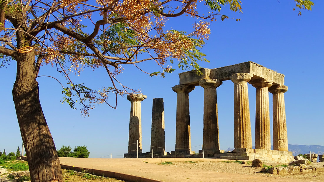
Corfu is a Greek island in the Ionian Sea. It is the second largest island of the Ionian Islands. According to Strabo, Corcyra was the Homeric island of Scheria and its earliest inhabitants were the Phaeacians. The island has indeed been identified by some scholars with Scheria, the island of the Phaeacians described in Homer's Odyssey, though conclusive and irrefutable evidence for this theory or for Ithaca's location have not been found. At a date no doubt before the foundation of Syracuse, Corfu was peopled by settlers from Corinth, probably 730 BC, but it appears to have previously received a stream of emigrants from Eretria. The commercially advantageous location of Corcyra on the way between Greece and Magna Grecia, and its fertile lowlands in the southern section of the island favoured its growth and, influenced perhaps by the presence of non-Corinthian settlers, its people, quite contrary to the usual practice of Corinthian colonies, maintained an independent and even hostile attitude towards the mother city. 7 day itinerary - On the Corfu Round
DAY 1 - CORFU CITY
Sightseeing of the old town and introductive talk about Magna Graecia Visit of the archaeological museums of Corfu and Paleopolis Video presentation about the Magna Graecia and lunch Visit of the Temple of Artemis, Mon Repos & Menecrates Monument Check-in, accommodation on board; Welcome meeting on boat; general cruise presentation Dinner at restaurant with sea view & night out. Return on board DAY 2- IOANNINA CITY Departure for Igoumenitsa port. Briefing and Video presentation of the Corfu Island and the route of the cruise Transfer by car to Dodoni. Visit of the Dodona Sanctuary Transfer by car to Ioannina. Visit of the archaeological museum Lunch in Ioannina with lake view Sightseeing of the town and visit of the picturesque isle in the lake Dinner in the isle of Ioannina Return to Igoumenitsa by car Overnight stay on board DAY 3 — SIVOTA - PARGA Departure to Sivota Stop in Karavostasi beach for a dive Arrive in Sivota. Lunch in a tavern with a sea view Departure for Parga Arrival in Parga, sightseeing Dinner on board and olive oil tasting experience DAY 4 — PARGA - AHERON Transfer by car to Nekrornanteion of Aheronta and visit of the site Activities & sports in Aherontas river (rafting, hiking etc) Return to Parga. Lunch near the port Video about pottery and discussion of the following activity - Pottery activity Dinner on board Departure for Antipaxi. Arrive during the night DAY 5 - ANTIPAXI Morning Dive & sea activities in Antipaxi Lunch in Antipaxi Sightseeing and tour of the island Video about ancient Greek food and discussion of the following activity Dinner on board on the traces of Ancient Greek food and wine tasting Departure for Paxi. Arrive during the night DAY 6- PAXI Morning Dive & tour of the island Lunch in Paxi Video about the environmental awareness and discussion of the Microplastics activity Night out Departure for Benitses. Arrive during the night DAY 7- BENITSES Archaeological site of Benitses Discussion of the trip (evaluation form, questionnaire) Lunch in Benitses Return in Corfu 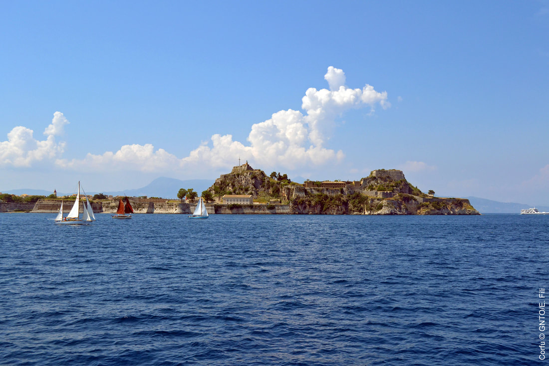
Delphi is in upper central Greece, on multiple plateaux along the slope of Mount Parnassus, overlooking the coastal plain to the south and the valley of Phocis. Delphi is famous as the ancient sanctuary that grew rich as the seat of Pythia, the oracle who was consulted about important decisions throughout the ancient classical world. Moreover, the Greeks considered Delphi the navel (or centre) of the world, as represented by the stone monument known as the Omphalos of Delphi. More specifically, in myths dating to the classical period of Ancient Greece (510-323 BC), Zeus determined the site of Delphi when he sought to find the centre of his "Grandmother Earth" (Gaia). He sent two eagles flying from the eastern and western extremities, and the path of the eagles crossed over Delphi where the omphalos, or navel of Gaia was found. The name Delphoi comes from the same root as δελφύς delphys, "womb" and may indicate archaic veneration of Gaia at the site. Apollo is connected with the site by his epithet "Δελφίνιος" Delphinios, "the Delphinian".
Delphi is now an extensive archaeological site with a modern town of the same name nearby. It is recognized by UNESCO as a World Heritage Site in having had a phenomenal influence in the ancient world, as evidenced by the rich monuments built there by most of the important ancient Greek city-states, demonstrating their fundamental Hellenic unity. The Archaeological Museum of Delphi is one of the most important museums not only of Greece, but also of the entire modern world. The exhibits that housed in its halls are among the most important discoveries in the history of civilisation, which come from the excavations of archaeologists in the field of the Oracle of Delphi, of the Navel of the Earth for the world of Greek antiquity. The exhibits cover the Greek antiquity from the foundation of the temple of Apollo in the 8th century B.C. to its decline in the years of late antiquity. The permanent exhibition of the Archaeological Museum of Delphi describes the story of the Delphic sanctuary and oracle based on a chronological framework. Its rich collections are composed primarily of architectural sculpture, statues and minor objects donated to the sanctuary. These reflect its religious, political and artistic activities from its early years in the eight century BC to its decline in Late Antiquity. Organised in fourteen rooms on two levels, the museum mainly displays statues, including the famous Charioteer of Delphi, architectural elements, like the frieze of the Siphnian Treasury and ex votos dedicated to the sanctuary of Pythian Apollo, like the Sphinx of Naxos. The exhibition floor space is more than 2270m2, while the storage and conservation rooms (mosaics, ceramics and metals) take up 558m2. Archaeological Site of Delphi. The Delphic sanctuary lies on the base of the gigantic rocks of Parnassus, the Phaedriades. The rocks are split forming an awesome chasm. Its clefts emitted the vapours in which the ancients saw the spirit of God and gave way to the waters of the sacred spring of Castalia; no one was allowed to seek Apollo's oracle before washed and purified in its waters. When approaching Delphi, the first site to be seen is the temenos of Athena Pronaia, the epithet meaning the goddess worshipped before the temple of Apollo. In this sanctuary is situated the renowned tholos of Delphi, a 4th century BC masterpiece of the ancient Greek architecture. The tholoi were circular structures, attributed to the cult of heroes or chthonic deities, an interpretation that remains uncertain in lack of ancient testimonies regarding their use. The type is found in other major sanctuaries as well, in Epidaurus and Olympia for instance. Higher still, a path leads from the theatre to the stadium, where the sporting events of the Pythian Games were held. The stadium acquired its final form during the 5th century BC and was able to hold 7000 spectators. Its length equals that of the Roman stadium, namely 177.55 m. - the Panathenaic stadium was 184.96 m long a). 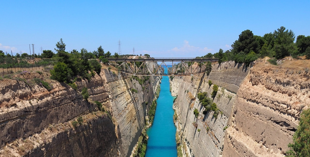 Located on the crossroads between mainland Greece and the Peloponnese and between the Saronic Gulf and the Corinthian Gulf, just 84 km from Athens, Corinth was an important city in Greek, Hellenistic and Roman times. In 734 BC Corinthians founded the city of Syracuse, the most powerful Greek colony of the Mediterranean, which is located on the southeast corner of the island of Sicily, next to the Gulf of Syracuse beside the Ionian Sea. The influence of the Corinthians is obvious up until today since the city is notable for its rich Greek history, culture, amphitheatres, architecture. The city of Corinth is filled with monuments, museums and historical sites: Ancient Corinth was one of the most important city-states of ancient Greece. Today in the archaeological site, one can visit the Temple of Apollo; its seven remaining Doric columns stand in a prominent position overlooking the ancient Agora. The temple was built in 530 BC, consisting of 2 rooms, and originally had 15 Doric-order columns along its length and 6 along its width. The city market had a rectangular shape, housing a number of similarly laid-out stores, each divided into 2 rooms. Its front was consisted by a double row of columns, the outer Doric and inner Ionic. In the ancient Agora, one can also visit the shops where the Apostle Paul once stood, along with the ancient Council. Descending the steps of the ‘propylaia’ (front gates) will lead you to Lecheou street where you will encounter the Pirene Fountain, with its six cave-like chambers, and the Glauki fountain standing carved in the rock. In the archaeological site you will also have the chance to visit the Odeon, built in the 1st century AD; and the 18,000-seat theater built in the fifth century BC, and later converted by the Romans into an arena for animal fights. Finally, you can walk through the remnants of the gymnasium and Temple of Asclepius near the Lerna fountain. Above Ancient Corinth lies the Castle of Akrocorinth, the Acropolis of the ancient city, which is itself worth a visit. Temple of Poseidon. The Archaic temple was constructed during the seventh century BC but was unfortunately destroyed by fire in the fifth century BC. It was subsequently rebuilt according to a Doric peripteral plan, from local Corinthian limestone, but was destroyed again in 390 BC. Again rebuilt, it flourished until 146 BC when the Roman consul Mummius destroyed the city. In 44 AD it was again rebuilt, but took its final form including the courtyard and colonnades during the second century AD. Corinth Canal. From ancient times, people have searched for an easier way to transfer ships from the Korinthian to the Saronic Gulf and vice versa. Created for this reason was the Diolkos, a paved road along which boats could be dragged across the isthmus. The Diolkos was constructed by the tyrant Periander of Korinthos, who had envisioned the opening of the canal. The opening of the canal had subsequently been attempted by Demetrios Poliorketes, Julius Caesar, Caligula, Nero, Herod Atticus, various Byzantines and Venetians, to no avail. The opening was re-launched by Kapodistrias but was again stopped due to lack of money. In 1881 the work of the excavation was undertaken by a Hungarian businessman, in exchange for a 99-year lease on the site, but who also abandoned the effort. The cutting was eventually completed thanks to the donation of Andreas Syngros. Over 10 years the Greeks finally managed to dig the canal, which opened on 25 July 1893. About 15,000 ships pass through the Canal of Korinthos every year. Crossing the Isthmus, the Six-Mile Wall (“Examilio Tichos”) stretches from the Saronic Gulf to the Corinthian Gulf. Built to protect against attack from the North, it is also known as the Justinian Wall. In its day, it was the largest protective wall in the Greek world, with a length of 7.5 km and a width of 3 m, with 67 watchtowers. It takes advantage of the lines of the natural landscape and was built (for better or worse) of recycled materials from classical-era structures, such as the nearby temple of Isthmian Poseidon.  Places of interest near Corinth Itea (Greek: Ιτέα meaning willow), is a town and a former municipality in the southeastern part of Phocis, Greece. Built in the background of the Crissaean Gulf extends together with the neighbouring Kirra, along the coastline of the plain sharing the same name, the Crissaean Plain and it is the south ending up of the famous landscape of Delphi. It is a relatively new city, since it was founded in 1830 and it managed to become soon an important commercial and transit centre due to a series of favourable circumstances. The access to the city is easy, either by sea - it has a good port that serves the transport of both people and goods - or by land, as it is connected to the big road axis of Greece. It constitutes the way out to the sea not only for the Department - it is the port of Amfissa and Delphi - but also for the entire area of Central Greece. Galaxidi or Galaxeidi is a town and a former municipality in the southern part of Phocis. Modern Galaxidi is built on the site of ancient Haleion, a city of western Locris. Traces of habitation are discernible since prehistoric times with a peak in the Early Helladic Period (Anemokambi, Pelekaris, Kefalari, islet of Apsifia). A significant Mycenaean settlement has been located at Villa; the hill of St. Athanasios also revealed a fortified Geometric settlement (ca. 700 BC). In the Archaic and Classical periods (7th-4th centuries BC) was developed the administrative and religious centre at the modern site of Agios Vlasis. It seems that in ca. 300 BC the present site was settled and surrounded by a fortification wall; it is the period of the expansion of power of the Aetolian League. Haleion flourished throughout the Hellenistic and Roman periods until the 2nd century AD. In an old mansion of Galaxidi are situated two museums:
 Ancient Oiniades was one of the most important towns of ancient Akarnania. According to some historians the city was founded in 6th century BC by the Corinthians. It flourished until the Hellenistic years. The ancient city of Oiniades was built on the north shore of the Acheloos River and 4 km west of the current village of Katochi. It held a strategic position from which both the entrance to the Patraikos Gulf and the motorway between Akarnania and the islands of Lefkada, Ithaca and Kefallonia were controlled. At the same time, it was situated near the estuary of Acheloos and therefore in a position suitable for harbour construction and commercial activity. The impressive city walls are well preserved. More specifically the fortification towers over an oak-covered hill, known as the Tricarch, are dated at least since the 15th century. Its preservation is impressive and is one of the most characteristic examples of ancient fortification art. At the top of the hill is the Acropolis with a separate enclosure. The walls, about 2,60 m, with a maximum preserved height of 6 m and about 6,5 perimeter, are built along their length along the polygonal system. A separate fortification encompasses its harbor and its harbors, the so-called "fortification or acropolis of the harbour". It includes twelve gates and pillars of different types, with the most remarkable type of gate. As for the towers, others were built in the polygonal system and others in the pseudo-isodomous table-shaped structure. This element of the coexistence of a polygonal wall with towers of polygonal and pseudo-isodomous bank-shaped walls is found in most of the fortifications of Akarnania. Within the fortification, the public buildings of the Agora (boulevard, gallery, building with houses, temple, Hero) are now visible, which have been investigated in recent years by El. Serbeti, Professor of the University of Athens, the so-called "Building on the Hill", excavated by the American archaeologist B. Powell at the beginning of the last century (1900-1901), the bath of the end of the Hellenistic period, as well as the theatre. Outside the walls, graves have been excavated from the eastern cemetery of the city. The only monument of the area and one of the most imposing of antiquity, due to its very good preservation, are the jungles or the shipyards. The junipers are located at the southwest end of the fortification of the harbour, dominated by the Red Tower, a preserved 10,90 m., And the oblique arched gate, the so-called "gates" (central photography), and the ruins of a second large size and oblique to the tower top that protects it. Furthermore, there is a large ancient theatre. The construction of it is dated in three periods. First, in the 4th century, was first built by the Athenians who occupied the city. Then, in the 3rd century, repairs were made, possibly by Macedonian Philip II. Later, 167 B.C. the Romans occupy the city and engage in small-scale modifications, which are not visible today. It is a good theatre, carved into the porous limestone rock of the slope. Unfortunately, the deterioration of the rock over the centuries has destroyed part of the pitches. It is considered to be a relatively large theatre, with 23 series of seats. Some stones in the lower row of seats have inscribed inscriptions with an ancient Greek script that has been read. The orchestra is particularly large with a radius as the outer circumference of the plates with 7,65 m. The scene behind the scenes formed a front of 27,70 m. Segments of shelves found around it are Ionic. The scene as it appeared was not elevated but terrestrial and thus provides a perfect view of the orchestra. The Theatre of Oiniades is built near the Agora in a position that offers stunning views of the surrounding lowlands, the old Acheloos river bed and the coastal areas. The existence of the theatre confirms the acme of this city. The hollow of the theatre, carved in the gray local limestone of the area, is larger than a semicircle and consists of twenty-seven rows of seats, of which only ten are preserved (initially it should have been twenty-nine or thirty). The viewers approached their positions through twelve climbs (now only nine are visible), dividing the hollow into eleven non-friezes. The theatre has very good acoustics and capacity that touches 5.500 viewers. The theatre recognises two building phases, mainly related to reconstructions of the stage building. The shipyard is a special monument of the area and one of the most imposing of antiquity because of its very good preservation. Shipyards were destined to haul the ships inside, repair and stay for a certain amount of winter. The junipers are located at the southwest end of the fortification of the harbour, dominated by the Red Tower, the 10,90 m., And the oblique arched gate, the so-called "gates", as well as the ruins of a second, also large and oblique in tower tower that protects it. It is a roofed building with a plan view of the 41 m. X 47 m., whose eastern side, about 11 m. Approx., Is almost entirely carved vertically on the natural rock. On the natural rock is also carved the floor. The interior of the building divided symmetrically five columns of seventeen stranded columns. The openings between the colonnades covered the long, elongated roofs with laconic tile. Between the colonnades six sixteenth "aisles" were developed with carved horseshoes and uphill to the depths of the newcomer floors. It is for the ramps in which the ships were dragged into the halls. On the eastern side of the monument there were eleven altogether rectangular pseudo-projections (about 7 m.), which formed twelve chambers, carved vertically on the rock. The piles were used to support, anchor and seal the roof of the monument on this side. The monument, dating back to the 4 century BC, has many architectural elements related to the jetties of Zea's harbour in Piraeus.  History Ancient Oiniades (Ancient Greek: Οἰνιάδαι) was a port town on the west bank of the river Achelous and one of the most important towns of ancient Acarnania. Oiniades was first mentioned in the 5th century B.C. It was situated against a hill in the marshes, which protected it from invaders. Its location has been identified to the west of the present village Katochi (Greek: Κατοχή). It was an important port on the route to Corfu as it changed its alliances repeatedly in the course of history. At first, it was a member of the Peloponnesian League, but in 424 B.C. it was incorporated in the Delian League. In the Hellenistic period, Oiniades allied with the Aetolians until 218 B.C. when Philip V declared it free. From 211-189 B.C., during the Roman-Macedonian wars, the city was again under Aetolian control. In Roman times, it lost its strategic importance. However, it was still inhabited in the 3rd century A.D. judging from coin findings. Ancient Oiniades is one of the many ancient cities in Aetolia and Akarnania that is mentioned in Greek myths and carries a long history. According to these myths, the first settler of the city was Alcmaeon from Argos. However, the city owes its name to King Oineas of Plevrona. Because of its location, (it was accessible by the river where at that time triremes would easily sail towards the city), it was one of the most important cities of Aetolia and Acarnania which fell under the rule of these two areas, interchangeably. In 454 B.C., the Messinians, exiled by the Spartans, occupied the city for one year, while during the Peloponnesian War (341-404 B.C.) the city played a crucial role in the conflicts between the Athenians and the Peloponnesians. In the centuries that ensued, the city found itself in the maelstrom of conflicts between the Aetolians and the Macedonians, until 219 A.D. when it was finally subjugated to Philip the Second of Macedon. The Aetolians, with the help of the Romans, re-conquered it, but in 189 A.D., it was subjugated to the Acarnanians. After 167 A.D., when the Romans prevailed throughout Greece, the city lost its historical identity, and until the 3rd century A.D. it became a small settlement. In antiquity, this fertile plain was Lake Meliti, created by the Acheloos River. The city was found on the delta of the Acheloos River, with the sea on its south and the lake at its north. It had two harbours, which are interred today. What remains from those impressive structures are the dockyards carved on the rocks. The walls of the city, which were built in the 5th century B.C., took their current shape in 219 B.C. when the city was conquered by Philip V of Macedon. The walls, of polygonal and at certain points regular masonry, are extended for about 6 km and cover a hilly area on the plain of the Acheloos river area. The ancient theatre, very well preserved, dates back to the 4th century B.C., built almost on the banks of the Acheloos River, at a distance of only 10 km from the mouth of the river and 3 km from the Ionian Sea and has seen two phases of construction, the latter of which was by the Romans. It had a big orchestra (15 m. in diameter), a skené, or stage, and proscenium of the 3rd century. Its cavea is separated into eight flights of steps and seven rows. Thirty rows of figurines carved on the rocks have been found at the theatre’s eastern part, while at its west, on the lower rows of the figurines, inscriptions of liberating slaves have been engraved. Thucydides, when describing the battles of the Athenians and the Spartans during the 3rd year of the Peloponnesian War, refers extensively to the unique location of the city, right on the banks of Acheloos, and how the overflowed latter turned the city into a swamp. Today, a very wide area of about 50 sqm has been filled with accumulated deposits of Acheloos and a lot of the islets of Echinadon, that were interspersed in antiquity, have now become parts of the land. Modern Oiniades is a municipal unit of the municipality Messolonghi. The municipal unit covers an area of 270.899 km2 and its population is about 9.000 people. 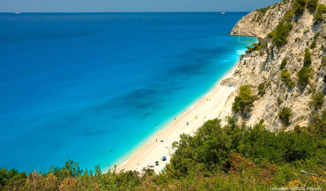 The ancient sources call Leucas a Corinthian colony, perhaps with a Corcyraen participation. Lefkada is a Greek island in the Ionian Sea on the west coast of Greece, connected to the mainland by a long causeway and floating bridge. Some scholars suggest that Lefkada was Homer's Ithaca, and the palace of Odysseus was located west of Nydri on the south coast of the island. The area of Apollonia's municipality had been inhabited at the very early days, as this is proved by some limited findings of Paleolithic and Neolithic period (3.500 BC) which were discovered from the excavations of the archaeologist Wilhelm Dorpfeld. In the valley of Vassiliki, the Archaelogical Service has discovered ancient archaeological ruins (ruins of towers), which probably belong to an ancient town and to the places of Marmara, Pyrgi, Klismatia, Marantochori. To the Cape of Doukato or Lefkata construction ruins and architectural parts Apollo Lefkata’s temple are located. This sanctuary was widely famous in the ancient world. Every year, Hellenic festivals have been taking place to the honour of Apollo, who was the protector of the marines and the doctor of body and soul. For this reason, ancients believed that, if you jump off the rocks, your soul would get free from the weight of passions and sins. In this place, the female poet Sappho allegedly leapt to her death from the 30 meters high cliffs. There is also an ancient wall and ruins of the ancient city “Nirikos”. Two km outside and east of the town, passing through the olive grove, one can reach Kalligoni. The area has been declared an archeological site and it embodies the ruins of the surrounding settlement of Ancient Lefkada, which are dated from Archaic to Roman times, two cemeteries of the ancient town, monuments, construction ruins, like graves, farmhouses and harbor facilities composing an integral part of the protected monumental place of the ancient town abandoned around 1300. The caste of Aghia Mavra is located at the entrance of the island. It is one of the most imposing medieval buildings of Greece, representing the fortification art of this period. It was built around 1300 from a Frank leader, Ioannis Orsini, when he took Lefkada as a wedding gift for his wedding with the daughter of Epirus Bishop Nikiforos A. The castle was protecting the capital of the island, as it was the most important defensive armoring against Pirates and other enemies, from the first decade of 14th century since 1684. In 1487, it was overtaken by Turks, who built a large arch shaped bridge with 360 rooms, which crossed the lagoon from the coast to Kalkani, with pipes of a water tower. This project was destroyed by the earthquakes. Some ruins are still preserved in the lagoon. The Lefkada Archaeological Museum is housed in the cultural center of the Borough of Lefkada (A. Sikelianou & N. Svoronou street). The findings exhibited cover a period of time, beginning in the middle of the Paleolithic times (200.000 - 35.000 π.Χ.) until the later Roman times. In a separate room at the museum, the findings of German archaeologist Wilhelm Dorpfeld are exhibited. He is the one who developed the theory that Lefkada is Homer’s Ithaca. The museum exhibits tools, ceramic and copper jewellery and gems of ancient tombs, mostly from the Ancient city of Nirikos, Nydri, Hoirospilia, Evgiros and the cave in Fryni. The “Pantazis Kontomixis” Folkloric Museum of the “Orpheus” Cultural Group is housed in the old town of Lefkada. It was founded in 1937 and includes many significant and rare exhibits, a rich collection of objects from the everyday life and business of the Lefkadite people. The Folkloric Museum of Lefkadite Canvas Works” Maria koutsohero”, in Karya village is in a small private museum in Karya Village. Among the traditional exhibit the visitor may discover the life and character, the persistence, patience and genius of the Lefkadite people, living in the highlands under rough conditions and managing to create a folkloric culture. There is also the museum of Angelos Sikelianos. In the two-storied house where Angelos Sikelianos was born and lived in Lefkada, it became possible to develop the vision and the act of the poet in a jewellery museum for an intellectual of worldview, a national pioneer, a real thinker, a politically present litterateur and a great lyric poet. The island of Lefkas or Lefkada or Lefkadia, at the time of Homer was known as the Niricos, as its capital was called. According to a prevailing view, the island owes its name to the steep white cliffs on its southernmost cape. Here is where legend states the poetess Sappho took her own life because her thwarted love for Phaon. The first traces of life on the island date to 8000 years before the birth of Christ, the Palaeolithic era. The German archaeologist Wilhelm Doerpfeld, an assistant to Heinrich Schliemann who discovered Troy and Mycenae, was the one who supported the theory that Lefkada is Homer’s Ithaca. In his excavations, in Nydri, he brought to light important findings from the Copper Age (about 2000 B.C.). The ancient Nikeos of the 7th century B.C., in which Kalligion at the “Koulmos” site was discovered, was the first capital of the island and was surrounded by a large wall. A small section of it, survives today. Moreover, the island was connected with Corinth and followed by participating in all great events of the ancient era. The Ionian Islands came to the Venetians in 1293. Afterwards, in 1300, the Castle of Aghia Mavra was built, where the capital was transferred. There follows a period that Venetians and Turks succeed each other, until 1503, when Lefkada was given with a treaty to the Turks. In 1684, was again occupied by Venetian Francis Morosini. The capital transferred out of the castle to its present location, called Amaksiki. People lost control of the harbor and trade from the Venetians. Separated from the rest of Greece and the Venetians and indifferent to develop a social and cultural background as Zakynthos and Corfu did, Lefkada struggled to create its own spiritual movement. Nevertheless, the Venetians organized public life, established courts and placed the foundations for the Administrative Services. In addition, there was an upcoming period of constant changes: • Venetian Rule: 1684 – 1797 • Democratic French: 1797 – 1798 • Russian Turks: 1798 – 1800 • Eptanisa State: 1800 – 1807 • Imperial French: 1807 – 1810 • English protection: 1810 – 1864 • Union with Greece on May 21, 1864. Lefkada and other Ionian islands become part of the Greek State. 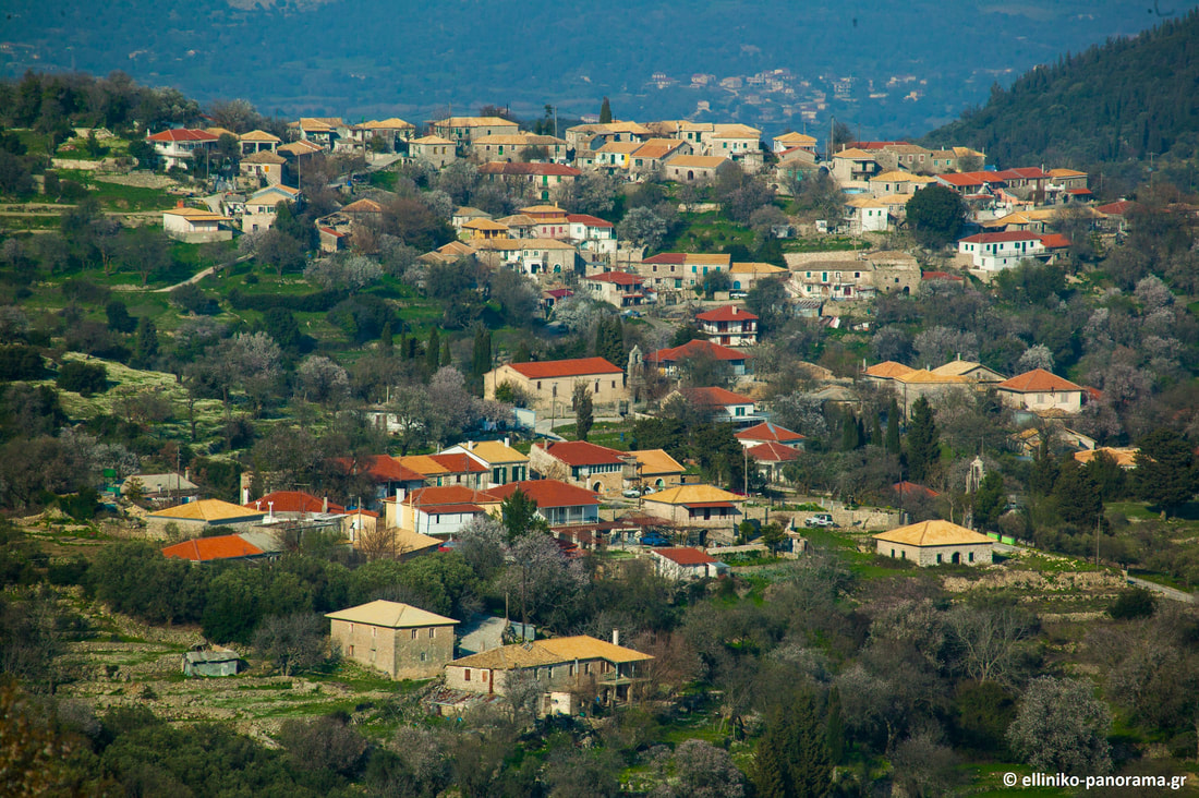 Attractions
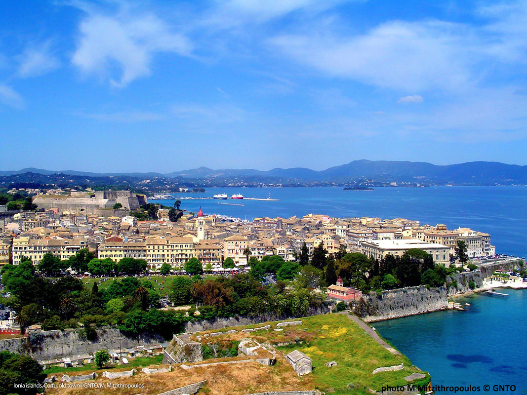 Corfu is a Greek island in the Ionian Sea. It is the second largest island of the Ionian Islands. According to Strabo, Corcyra was the Homeric island of Scheria and its earliest inhabitants were the Phaeacians. The island has indeed been identified by some scholars with Scheria, the island of the Phaeacians described in Homer's Odyssey, though conclusive and irrefutable evidence for this theory or for Ithaca's location have not been found. At a date no doubt before the foundation of Syracuse, Corfu was peopled by settlers from Corinth, probably 730 BC, but it appears to have previously received a stream of emigrants from Eretria. The commercially advantageous location of Corcyra on the way between Greece and Magna Grecia, and its fertile lowlands in the southern section of the island favoured its growth and, influenced perhaps by the presence of non-Corinthian settlers, its people, quite contrary to the usual practice of Corinthian colonies, maintained an independent and even hostile attitude towards the mother city. The ancient city of Corfu (Paleopoli) evolved in the archaic years between two natural harbours, the one of Alkinoos and the Ellaiko (Chalkiopoulos lake). The archaeological sites are scattered all over the peninsula of Kanoni, now a suburb of the modern city. Archeological excavations brought to light sacred groves,relics of temples, houses, workshops, baths, a public market, shipyards, works of art, every day and worship objects. In Paleopoli there is the temple of Artemis Gorgo is one of the earliest Doric temples made completely out of stone and has seventeen pillars on each long side and six on each short one. The Temple has a well-preserved, huge altar (in situ) and was built in 590-580 B.C. from porous limestone. The spectacular representation on the relief pediment of the west side is at the Archaeological Museum, since the “pediment of Gorgo” is the oldest stone pediment found in Greece. The Temple was discovered in 1822 A.D. by the British Officer Whitmore, under the supervision of the German archaeologist Dorpfeld. At the east of Paleopolis there is the Mon Repos estate. There is a late Archaic (around 500 B.C.) Doric temple with eleven one-stone pillars on each long side and six on each short one. The temple is dedicated to an unidentified deity. Moreover, there is the sanctuary of Hera Acraia. Only the foundations of the Heraion are preserved. It should be mentioned that the Mon Repos estate is a neoclassical building at the east of Paleopolis and was built by the British Commissioner Sir Frederick Adams in 1830. It was latterly used by the former royal family as a summer residence and it was the birth place for Prince Philip, Duke of Edinburgh. Mon Repos estate is not an ancient monument but is located within the area of ancient Corfu and in addition now houses the museum of Paleopolis. In Paleopoli one of the towers of the fortification of the ancient city (5th-4th century B.C.) is preserved. It was later incorporated into the Church of Virgin Mary of Neratzicha. Parts of the town fortification from the 5th century B.C. have also been discovered in the “Ellaiko” harbour. In Chalkiopoulos lake there are parts of the port facilities at the “ Ellaiko” harbour of the ancient city as well as at the harbor of Alkinoos (7th-1st century B.C.), which was used as a place to keep ships in winter. In Paleopoli one can see one of the towers of the fortification of the port of the ancient city, known as "Port of Alkinoos." It was discovered in the foundations of the church of Ag. Athanasios, built in the 18th century. The Corfu Archaeological museum is located in Garitsa near the seaside boulevard in the street of Armeni Braila. Built in the 60s under the standards followed then for buildings intended to be Museums and started its operation at September of 1967. It is the larger of Corfu museums, a two floor building with a courtyard garden and a balcony at the south and east side of the first floor. The vast bulk of the exhibits are located on the first floor which comprises by four rooms and a hallway. The largest western hall along with other artefacts from ancient temples of Palaiopolis is the pediment of the Temple of Artemis in 580 B.C. with gigantic dimensions, 17 meters width and 3 meters height and its central theme is the mythical monstrous Gorgon. Major exhibits are the archaic funerary lion of Menekratis (late 7th century bc) found in the circular cenotaph of Menekratis, the left side of an archaic pediment (the pediment of Dionysus 500 BC) with dimensions of 2.73 meters long and about 1 meter in height that was found in Figareto and depicts of a Dionysiac banquet scene, the bronze statuette of a young “komastos” (570 BC) who runs and on his left hand holds a “rhyton”, the head of a kouros of 6th century b.c which was found in excavations of Paleopolis in Mon Repos, a clay statuette of Artemis (490 BC) found in Kanoni, the kouros of Corfu (530 BC) from Parian marble headstone and the Arniada (630-600 BC) found in the ancient cemetery near Garitsa. In the museum there are finds of Palaeolithic and Early Bronze Age as well as recent articles of the Hellenistic and Roman period. The home of our National poet Dionisios Solomos in the third end of Arseniou street at Mouragia has been turned into a museum. It is the place where the Poet lived for 30 years and inspired his poems. It presents furniture, personal items, photographs and historical material from his life. In Benitses there is the Corfu shell museum with one of Europe’s largest collection of shells and other marine species. This museum is unique not only because it is one of the few of its kind in Greece but also because the rich collection consists of very rare and beautiful marine species, some of which claim Guinness awards due to their rarity and beauty. Created by the diver and collector Napoleon Sagias, who enriched the museum with rare findings collected during his 20 years travelling in the Indian and Pacific Oceans, diving and collecting shells. The Folklore museum in Acharavi is housed in two rooms of a building situated just opposite the ancient Roman baths in the seaside village of Acharavi in centre northern Corfu. In the museum there is an interesting collection of folklore items mainly from the region of northern Corfu, objects mainly household as furniture, a loom, a traditional mill for kitchen utensils and agricultural tools of past centuries, a watermill, church supplies and other items showing the historical evolution of Corfu since then.  Attractions
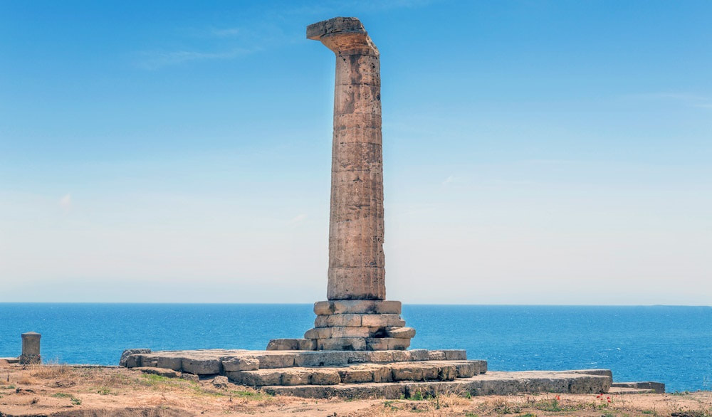 The promontory of Capo Colonna hosts the homonymous Archaeological Park, where anciently the great Heraion Lakinion was located. The Park extends along 30 hectares of land used as excavations, and another 20 hectares covered by a wood and the typical “Macchia Mediterranea”. The Heraion Lakinion was one of the most famous sacred areas of the entire Mediterranean basin related to the majestic sanctuary dedicated to the goddess Hera Lacinia. The entrance to the Park consists of the new Archaeological Museum, a structure with three pavilions built into the ground to reduce the environmental impact, which collects the finds found in the excavation area in front. A long tree-lined avenue, immersed in the luxuriant “Macchia Mediterranea”, leads to the first evidence of the Archaeological Park. At the end of the avenue, there are the walls of the VI century BC. They were reinforced later by the Romans and of which the opus reticolatum is clearly visible. Crossing the entrance of the Via Sacra, 8.5 meters wide and partially discovered in 1987, it is possible entering the area of the sanctuary of Hera Lacinia, well protected by the large curtain wall reinforced to the north and south by two external towers. The sacred area is divided into two zones oriented to the east, and crossed by the solemn Via Sacra. The Katagogion, a hotel for privileged pilgrims, is aligned towards the north side and shows a peristyle with stuccoed columns and capitals of the Doric order of the second half of the 4th century BC. The Hestiatorion, a building for banquets, located along the south side of the track is dated back to this period. The two buildings are not yet fully investigated. The temple of Hera Lacinia, the most important attraction of the park, is opposite the entrance of the Via Sacra, on the east side of the promontory of Capo Colonna. The temple was realized in Doric style with a rectangular plan of 6x19 columns and it dates back to the 5th century BC. Unfortunately today only a column with stilobate remains of the temple: Doric style, 8.5 meters high with 20 flat grooves, and the powerful base composed of 10 levels of squared blocks. It was found next to the temple the foundations of a large building called B with a rectangular plan of 22x9 meters. In the area outside the sanctuary, but still inside the Archaeological Park, various domestic environments have been excavated, suggesting the priests' quarters, a Roman bath balneum, and a Roman villa, both of the III century AD. The conspicuous objects found during the excavations in the Archaeological Park are divided among the different museums of the city of Crotone. The last discoveries are found in the new and adjacent Museum of Capo Colonna, while something of the pre-colonial era is exhibited in the Antiquarium of Torre Nao, located inside the Archaeological Park. The first finds of the Archaic period and above all the precious Treasure of Hera are placed in the National Archaeological Museum of Crotone. Attractions
 (Photo: Fabrizio Mauri) Le Castella town of Isola Capo Rizzuto represents what remains of a more large ancient area. The fortress is surrounded by the Capo Rizzuto Marine Reserve and from one of the rooms it is possible to observe the seabed thanks to of underwater cameras positioned in marine environment.
The fortress built in the fifteenth century never hosted the nobility of the place but served as a shelter for soldiers committed against attacks by invaders from the sea. The current stronghold rests on foundations dating back to the Hellenistic period, used over time also by the Romans was the retreat of Hannibal. Even today it is possible to notice the different building phases superimposed on each other in different periods, Normans, Swabians, Byzantines, Angevins and Aragoneses who raised on the Greek walls strong defences castellane modelled according to the times. The fortress continually attacked by the Turks, remained populated until the beginning of the 800, when the population moved to the mainland giving life to a small village of sailors, today the current tourist center. The original unit of the fort goes back to the Angevin Age, and the massive cylindrical tower as well. Now it has a sixteenth-century shape and it dominates the fortress complex with its magnificence. The original plant of 13th century was built to defend the Gulf of Capo Rizzuto, and it is part of the Angevin system of fortifications. Towards the end of the 15th century the fortress passed in Aragonese hands and between 1510 and 1526 Earl Carafa implemented, according to the Spanish construction uses, the quadrangular rammed bastions. The tower, divided into three floors connected by a spiral staircase, presents at the base a cavity for the collection and conservation of rainwater. Inside of fortress there are typical remains of an urban agglomeration, a kind of small village with shops and the ruins of a little church. Le Castella was often the centre of strong quarrels and subjected to pirates attacks: in 1459 the King Ferdinando of Aragon came down on the battlefield, against the noble feudatory, Antonio Centelles. Then Castella was submitted to different noble families such as Carafa, Ruffo, Filomarino, Baraccos and Berlingeris. Between 1548 and 1553 the pirates Dragut and Barbarossa pillaged the area. In 1799 Castella was still the centre both of the fight between French and Bourbons and the landing-place for the troops coming from Sicily. Later, Castella was included first in the district of Crotone and then it became a part of the Isola di Capo Rizzuto. Located nearby to the Aragonese fortress, “Le Castella” seabed hosts the ruins of an ancient Greek quarry along with those of an imposing wreck; while at “Capo Alfieri” site, divers will be able to explore some ancient Roman millstones. ARMATA BRANCALEONE FILM The Aragonese Fortress was chosen by Mario Monicelli to set some scenes of “Armata Brancaleone” movie. Brancaleone (Vittorio Gassman) succumbs ingloriously to the assault of Saracen pirates with his shabby company, after taking possession of the fiefdom, abandoned by the local population too. THE PIRATE UCCIALÌ Uluc Pasha, a powerful Turkish admiral, born in Le Castella, was kidnapped as a boy and became part of the ranks of Barbary pirates, up to the summit of the army and power. His ability and his strength as well as his origin particularly impressed the Italian companies of the sixteenth century. According to historical reconstructions, Giovan Dionigi Galeni was entering a convent to become a monk when, at 16, he was captured by the Algerian corsair Khayr al-Dīn Barbarossa in 1536, in Le Castella. The prisoner-boy was immediately put on the oars as a slave, but managed to survive thanks to an uncommon resistance and to the understanding of the enemy's codes. In this change, he was helped by contact with barbarian corsairs of Calabrian origin, including Ja 'Far Pascià, whose daughter he married, after having converted to Islam in order to be able to kill without a consequence a Turk from whom he had been offended. The audacity of the failed Calabrian friar was enormous. As a privateer he raged throughout the Mediterranean and carried out acts of reckless robbery. He landed the Sicilian and Neapolitan coasts and woods, captured ships, attacked towns and cities, until he went to Liguria in Civezza, currently in the province of Imperia, which managed to resist him gloriously and also attacked the Dalmatian town of Korcula. He tried to capture the Duke Emanuele Filiberto of Savoy. His sea races therefore also had wide-ranging political goals. It was said that he had even tried, through strong local support, to turn Calabria into a Turkish-dominated Muslim region, snatching it from the Spaniards. He first became commander of the fleet of Alexandria, then Pasha of Algiers, and finally bey (governor) of Tripoli, became admiral of the Ottoman fleet, fought in Lepanto. In Italy, the former aspiring monk was called "the renegade" or, popularly Uccialì, which derives from his Islamic name. He died in July 1587 in his palace on the hilltop of Top-Hana near Istanbul and left his many slaves and servants houses and possessions of property, concentrated in a village he founded and called "New Calabria". According to some reports, on his deathbed he would return to the Christian faith, but the Turkish historians denied this eventuality, given that already in life he had been offered fiefs and riches in Christian lands that he had always refused, preferring the freedom of which Christians converted to Islam at that time enjoyed. (Source: www.stilearte.it) Attractions
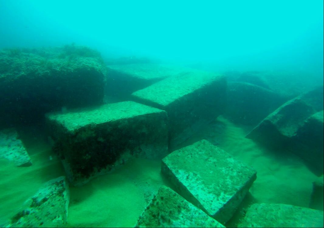 The wreck lies in the bay of Scifo, just south of the promontory of Capo Colonna (ancient Lacinium promontoriu, site of the sanctuary dedicated to Hera). It lies on the seabed at a depth of 6.5 m and 160 m from the promontory of Capo Pellegrino, known locally as Punta Scifo. Discovered by Luigi Canfora in 1986, the wreck was investigated in 1987 by the Cooperativa Aquarius, directed by Alice Freschi, on behalf of the Archaeological Superintendency of Calabria. These investigations, including excavation and planning, remained largely unpublished. The site has been newly investigated using new technology and cataloguing has begun of the moveable finds (metal and ceramics) recovered during the 1987 campaign and largely forming part of the ship’s equipment. The archaeological deposit “Punta Scifo D” comprises over 50 marble artefacts belonging to the cargo of a stone transporting ship, which a preliminary study of the pottery and amphorae dates to the 3rd century A.D. The marbles, in the form of blocks and slabs, are all in the rough-hewn stage and some are very large weighing over 20 tons. Minero-petrographic and isotope analyses undertaken by Lorenzo Lazzarini, I.U.A.V (Venice) on a series of samples, indicate that this is Proconnesian marble quarried at the site of Saraylar on the Turkish island of Marmara. During the 2011 investigation, a photo-mosaic was made of the entire area where the stone elements lie and all of them were re-measured in order to determine the volume and weight of the cargo on the ship. The first results suggest that the “Punta Scifo D” ship transported one of the largest ancient stone cargoes discovered in the Mediterranean. Study and processing of the data is underway and this should make it possible to determine the original positions in stowage of the stone blocks and to understand what the maximum dimensions and hydro-static characteristics of the ship were. The few preserved timber remains from the hull showed the use of a double layer mortice and tenon construction technique. Like the marble’s provenance, some of the ships equipment (pottery and amphorae) was linked to productions in the Aegean-Microasiatic and Pontine areas. Attractions
|